
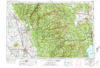
~ Chico CA topo map, 1:250000 scale, 1 X 2 Degree, Historical, 1958, updated 1973
Chico, California, USGS topographic map dated 1958.
Includes geographic coordinates (latitude and longitude). This topographic map is suitable for hiking, camping, and exploring, or framing it as a wall map.
Printed on-demand using high resolution imagery, on heavy weight and acid free paper, or alternatively on a variety of synthetic materials.
Topos available on paper, Waterproof, Poly, or Tyvek. Usually shipping rolled, unless combined with other folded maps in one order.
- Product Number: USGS-5506513
- Free digital map download (high-resolution, GeoPDF): Chico, California (file size: 26 MB)
- Map Size: please refer to the dimensions of the GeoPDF map above
- Weight (paper map): ca. 55 grams
- Map Type: POD USGS Topographic Map
- Map Series: HTMC
- Map Verison: Historical
- Cell ID: 72222
- Scan ID: 299747
- Imprint Year: 1973
- Woodland Tint: Yes
- Aerial Photo Year: 1969
- Edit Year: 1970
- Field Check Year: 1958
- Datum: Unstated
- Map Projection: Transverse Mercator
- Map published by: Military, Other
- Map Language: English
- Scanner Resolution: 600 dpi
- Map Cell Name: Chico
- Grid size: 1 X 2 Degree
- Date on map: 1958
- Map Scale: 1:250000
- Geographical region: California, United States
Neighboring Maps:
All neighboring USGS topo maps are available for sale online at a variety of scales.
Spatial coverage:
Topo map Chico, California, covers the geographical area associated the following places:
- Foresthill - Cal-Ida - Lake Wildwood - Cedar Mill - Anita - Kings Beach - Thermalito - Hawley - Union Mills - Butte House (historical) - Rodgers Flat - Mount Hope House (historical) - Milton (historical) - Sunnyslope - Evergreen Estates - Poker Flat - Chambers Lodge - Honcut - Alpine Meadows - Ostrom - Woodleaf - Hughes Place - Little York (historical) - Spruce (historical) - Hawk Ravine (historical) - Sycamore - Mabie - Sutter - Newtown - Union Hill - Vinboy Trailer Park - Carvin Creek Homesites - Bullards Bar (historical) - Dodge Place - Maybert (historical) - Yankee Jims - Garden Valley (historical) - South Oroville - Forest Ranch - Crystal Springs (historical) - Lake City - Beckwourth - Camp Spaulding - Sicard Flat - Alleghany - Cedar Crest - Crystal Lake - Ramirez - Quincy - McMahons (historical) - Lira - Prosser Lakeview Estates - Palmetto - Hammonton - Chico - Bronco - Tarke - Brockway - Sierraville - Big Ripples (historical) - Queen City - Bontes (historical) - Ridge View - Twin Peaks Estates - Nevada City - Bear River Pines - Carnelian Bay - Echo Ridge Trails - Oroville Junction - Calvada (historical) - Plum Valley - Gelatt - Fagan - Big Oak Valley - Camp Eighteen - West Butte - Last Chance - Rainbow - Sweetland - Mount Vernon (historical) - Bridgeport - Abbott - Ponderosa Palisades - Four Acres - Hallelujah Junction - Tobin - East Quincy - French Corral - Rogerville - Sunrise Heights - Tierra Buena - Massack - Rock Crest - Whitehawk - Galena Hill (historical) - Craig (historical) - Truckee - Forest Knolls - Merlin - Clipper Mills
- Map Area ID: AREA4039-122-120
- Northwest corner Lat/Long code: USGSNW40-122
- Northeast corner Lat/Long code: USGSNE40-120
- Southwest corner Lat/Long code: USGSSW39-122
- Southeast corner Lat/Long code: USGSSE39-120
- Northern map edge Latitude: 40
- Southern map edge Latitude: 39
- Western map edge Longitude: -122
- Eastern map edge Longitude: -120


