
~ Bakersfield CA topo map, 1:250000 scale, 1 X 2 Degree, Historical, 1948, updated 1948
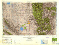
Bakersfield, California, USGS topographic map dated 1948.
Includes geographic coordinates (latitude and longitude). This topographic map is suitable for hiking, camping, and exploring, or framing it as a wall map.
Printed on-demand using high resolution imagery, on heavy weight and acid free paper, or alternatively on a variety of synthetic materials.
Topos available on paper, Waterproof, Poly, or Tyvek. Usually shipping rolled, unless combined with other folded maps in one order.
- Product Number: USGS-5506507
- Free digital map download (high-resolution, GeoPDF): Bakersfield, California (file size: 13 MB)
- Map Size: please refer to the dimensions of the GeoPDF map above
- Weight (paper map): ca. 55 grams
- Map Type: POD USGS Topographic Map
- Map Series: HTMC
- Map Verison: Historical
- Cell ID: 68661
- Scan ID: 707206
- Imprint Year: 1948
- Woodland Tint: Yes
- Aerial Photo Year: 1944
- Datum: NAD27
- Map Projection: Transverse Mercator
- Shaded Relief map: Yes
- Map published by United States Army Corps of Engineers
- Map published by United States Army
- Map Language: English
- Scanner Resolution: 508 dpi
- Map Cell Name: Bakersfield
- Grid size: 1 X 2 Degree
- Date on map: 1948
- Map Scale: 1:250000
- Geographical region: California, United States
Neighboring Maps:
All neighboring USGS topo maps are available for sale online at a variety of scales.
Spatial coverage:
Topo map Bakersfield, California, covers the geographical area associated the following places:
- Missouri Triangle - Myricks Corner - Isabella (historical) - Dow - Glennville - Kayandee - Scovern Hot Springs (historical) - Oildale - Reefer City (historical) - Strand (historical) - Little Dixie (historical) - Johnsondale - Leonards (historical) - Panama - Miracle Hot Springs - Shirley Meadows - Camp Owens - Ford City - Trescape (historical) - Jastro - Fleta - Pixley - Weedpatch - Asphalto (historical) - San Emidio - Mexican Colony - Bowerbank - Sugarloaf Village - White River Summer Home Tract - Kettleman Station - Walong - Sage (historical) - Stevens - Guernsey Mill - North Shafter - Panorama Heights - Canebrake (historical) - Keyesville - Hazelton - Tupman - Conner - Chaffee - Paloma (historical) - Mayfair - Alpaugh - Cawelo - Lost Hills - Olig (historical) - Wallace Center - Delano - Kilowatt - Fuller Acres - Cable - Balance Rock - Terra Bella - Cinco - Minter Village - Lokern - Marcel - Shady Rest (historical) - Lake Isabella - Shafter - Elmo - Rosedale - El Rita - Pumpkin Center - Kernell - Rowen - Lempon (historical) - Inmans (historical) - McFarland - Hights Corner - Spellacy - Cherokee Strip - Spicer City - Petersburg (historical) - Wofford Heights - Treves (historical) - Cambio (historical) - Slater - Ilmon - Sugarloaf Mountain Park - Trocha - Cameron - Semitropic - Spear Creek Summer Home Tract - Lackey Place - Seguro - Mojave - Lamont - Thomas Lane - Alameda - La Rose (historical) - McKittrick - Taft - Warren (historical) - Venola - Mitchells Corner - Pleasant View - Radnor
- Map Area ID: AREA3635-120-118
- Northwest corner Lat/Long code: USGSNW36-120
- Northeast corner Lat/Long code: USGSNE36-118
- Southwest corner Lat/Long code: USGSSW35-120
- Southeast corner Lat/Long code: USGSSE35-118
- Northern map edge Latitude: 36
- Southern map edge Latitude: 35
- Western map edge Longitude: -120
- Eastern map edge Longitude: -118


