
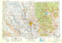
~ Bakersfield CA topo map, 1:250000 scale, 1 X 2 Degree, Historical, 1962, updated 1973
Bakersfield, California, USGS topographic map dated 1962.
Includes geographic coordinates (latitude and longitude). This topographic map is suitable for hiking, camping, and exploring, or framing it as a wall map.
Printed on-demand using high resolution imagery, on heavy weight and acid free paper, or alternatively on a variety of synthetic materials.
Topos available on paper, Waterproof, Poly, or Tyvek. Usually shipping rolled, unless combined with other folded maps in one order.
- Product Number: USGS-5506505
- Free digital map download (high-resolution, GeoPDF): Bakersfield, California (file size: 16 MB)
- Map Size: please refer to the dimensions of the GeoPDF map above
- Weight (paper map): ca. 55 grams
- Map Type: POD USGS Topographic Map
- Map Series: HTMC
- Map Verison: Historical
- Cell ID: 68661
- Scan ID: 707205
- Imprint Year: 1973
- Woodland Tint: Yes
- Visual Version Number: 1
- Aerial Photo Year: 1971
- Edit Year: 1971
- Field Check Year: 1962
- Datum: Unstated
- Map Projection: Transverse Mercator
- Map published by United States Geological Survey
- Map Language: English
- Scanner Resolution: 508 dpi
- Map Cell Name: Bakersfield
- Grid size: 1 X 2 Degree
- Date on map: 1962
- Map Scale: 1:250000
- Geographical region: California, United States
Neighboring Maps:
All neighboring USGS topo maps are available for sale online at a variety of scales.
Spatial coverage:
Topo map Bakersfield, California, covers the geographical area associated the following places:
- Famoso - Elmco - Halfway House - Marcel - Meridian - Panorama Heights - Sand Canyon - Cameron - Idlewild - Hazelton - McFarland - Radnor - Golden Hills - Buttonwillow - Cherokee Strip - McKittrick - Oildale - Vaccaro (historical) - Lempon (historical) - Slater - Cambio (historical) - Shirley Meadows - Zentner - Chaffee - Levee (historical) - Ford City - North Belridge - Little Dixie (historical) - Vestal - Alameda - Bowerbank - Redwood Corral - Greenfield - Ilmon - West Alpaugh (historical) - White River - Cawelo - Delano Mobile Home Park - Woody - Old River - Lokern - Cinco - Caliente - Mitchells Corner - Roads End - Poso Park - Sullivan (historical) - Spear Creek Summer Home Tract - Bella Vista - Pleasant View - Ribier - Mexican Colony - Maltha - Fuller Acres - Trocha - Monolith - Lake Isabella - Ultra - Canebrake - Squirrel Mountain Valley - Spicer City - Shady Rest (historical) - Kilowatt - Kern - Old Town - Trescape (historical) - Bakersfield - Warren (historical) - Bealville - Pettit Place - Saco - Neuralia (historical) - Leonards (historical) - Alta Sierra - Landco - Wolforts (historical) - Thomas Lane - Pentland - Woodford - Mountain Mesa - Scovern Hot Springs (historical) - Jastro - Derby Acres - Weedpatch - Rio Bravo - Arvin Mobile Home Estates - Alpaugh - Bear Valley Springs - Calico - Taft Heights - Richgrove - Treves (historical) - Millux - Orris - Magunden - South Taft - Fram (historical) - Onyx - Isabella (historical) - Wallace Center
- Map Area ID: AREA3635-120-118
- Northwest corner Lat/Long code: USGSNW36-120
- Northeast corner Lat/Long code: USGSNE36-118
- Southwest corner Lat/Long code: USGSSW35-120
- Southeast corner Lat/Long code: USGSSE35-118
- Northern map edge Latitude: 36
- Southern map edge Latitude: 35
- Western map edge Longitude: -120
- Eastern map edge Longitude: -118


