
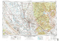
~ Bakersfield CA topo map, 1:250000 scale, 1 X 2 Degree, Historical, 1962, updated 1973
Bakersfield, California, USGS topographic map dated 1962.
Includes geographic coordinates (latitude and longitude). This topographic map is suitable for hiking, camping, and exploring, or framing it as a wall map.
Printed on-demand using high resolution imagery, on heavy weight and acid free paper, or alternatively on a variety of synthetic materials.
Topos available on paper, Waterproof, Poly, or Tyvek. Usually shipping rolled, unless combined with other folded maps in one order.
- Product Number: USGS-5506503
- Free digital map download (high-resolution, GeoPDF): Bakersfield, California (file size: 22 MB)
- Map Size: please refer to the dimensions of the GeoPDF map above
- Weight (paper map): ca. 55 grams
- Map Type: POD USGS Topographic Map
- Map Series: HTMC
- Map Verison: Historical
- Cell ID: 68661
- Scan ID: 299734
- Imprint Year: 1973
- Woodland Tint: Yes
- Aerial Photo Year: 1971
- Edit Year: 1971
- Field Check Year: 1962
- Datum: Unstated
- Map Projection: Transverse Mercator
- Map published by: Military, Other
- Map Language: English
- Scanner Resolution: 600 dpi
- Map Cell Name: Bakersfield
- Grid size: 1 X 2 Degree
- Date on map: 1962
- Map Scale: 1:250000
- Geographical region: California, United States
Neighboring Maps:
All neighboring USGS topo maps are available for sale online at a variety of scales.
Spatial coverage:
Topo map Bakersfield, California, covers the geographical area associated the following places:
- Zentner - Asphalto (historical) - Levee (historical) - Alta Sierra - Panorama Heights - Petersburg (historical) - Old Town - Bella Vista - Neuralia (historical) - Trescape (historical) - Ultra - Richgrove - Patch - Crome - Havilah - Kettleman Station - Camp Owens - Rio Bravo - Myricks Corner - Riverkern - Ford City - Burton Mill - Guernsey Mill - Lackey Place - Stallion Springs - Golden Hills - Ducor - Claraville - Sageland - South Lake - Warren (historical) - Maricopa - Simmler - Thomas Lane - Angiola - Hazelton - Reward - Landco - Bena - Woodford - Spa (historical) - Kernville (historical) - Fruitvale - Stevens - Sugarloaf Village - Bakersfield - Glennville - Slater - Bowerbank - Eric (historical) - Caliente - Valley Acres - Wofford Heights - Jasmin - Elmo - Redwood Corral - Spellacy - Gulf - Deer Creek Colony - Cambio (historical) - Kyan (historical) - Canebrake - Inmans (historical) - Jastro - Lonsmith - Old River - Isabella (historical) - Terra Bella - Dow - Millux - Keene - Shafter - Keyesville - Bodfish - Kernell - Fig Orchard - Strand (historical) - Pentland - Spicer City - Semitropic - West Alpaugh (historical) - Calders Corner - Pine Flat - Oildale - Delano Mobile Home Park - Panama - Elmco - El Rita - Lake Isabella - Sand Canyon - Little Dixie (historical) - Twin Oaks - Kernville - Pond - Quailwood - Shirley Meadows - Stoil - Roads End - Radnor - Calico
- Map Area ID: AREA3635-120-118
- Northwest corner Lat/Long code: USGSNW36-120
- Northeast corner Lat/Long code: USGSNE36-118
- Southwest corner Lat/Long code: USGSSW35-120
- Southeast corner Lat/Long code: USGSSE35-118
- Northern map edge Latitude: 36
- Southern map edge Latitude: 35
- Western map edge Longitude: -120
- Eastern map edge Longitude: -118


