
~ Bakersfield CA topo map, 1:250000 scale, 1 X 2 Degree, Historical, 1962, updated 1973
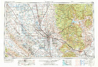
Bakersfield, California, USGS topographic map dated 1962.
Includes geographic coordinates (latitude and longitude). This topographic map is suitable for hiking, camping, and exploring, or framing it as a wall map.
Printed on-demand using high resolution imagery, on heavy weight and acid free paper, or alternatively on a variety of synthetic materials.
Topos available on paper, Waterproof, Poly, or Tyvek. Usually shipping rolled, unless combined with other folded maps in one order.
- Product Number: USGS-5506501
- Free digital map download (high-resolution, GeoPDF): Bakersfield, California (file size: 23 MB)
- Map Size: please refer to the dimensions of the GeoPDF map above
- Weight (paper map): ca. 55 grams
- Map Type: POD USGS Topographic Map
- Map Series: HTMC
- Map Verison: Historical
- Cell ID: 68661
- Scan ID: 299733
- Imprint Year: 1973
- Woodland Tint: Yes
- Visual Version Number: 2
- Aerial Photo Year: 1971
- Edit Year: 1971
- Field Check Year: 1962
- Datum: Unstated
- Map Projection: Transverse Mercator
- Map published by: Military, Other
- Map Language: English
- Scanner Resolution: 600 dpi
- Map Cell Name: Bakersfield
- Grid size: 1 X 2 Degree
- Date on map: 1962
- Map Scale: 1:250000
- Geographical region: California, United States
Neighboring Maps:
All neighboring USGS topo maps are available for sale online at a variety of scales.
Spatial coverage:
Topo map Bakersfield, California, covers the geographical area associated the following places:
- Panorama Heights - Sugarloaf Saw Mill - Kernville - Edmundson Acres - Camp Owens - Shady Rest (historical) - Gold Town (historical) - Bowerbank - Famoso - Hazelton - Wofford Heights - Pleasant View - Lokern - Stone Place - South Lake - Pond - Leonards (historical) - Bena - Angiola - Vinland - Cypress Gardens Mobile Home Community - Alpaugh - Fig Orchard - Wheeler Ridge - Oildale - Twin Oaks - Elmco - Mexican Colony - Jasmin - Shirley Meadows - Balance Rock - Magunden - Una - Loraine - Saucelito - Rock Springs (historical) - Golden Hills - Keene - Alta Sierra - Canebrake (historical) - Mettler - North Belridge - Spa (historical) - Lamont - Edison - Redwood Corral - Gulf - Deer Creek Colony - Taft Heights - Kernell - Lempon (historical) - Sullivan (historical) - Guernsey Mill - Pentland - Reefer City (historical) - Greenacres - Walong - Fellows - Old Town - Derby Acres - Alameda - Elmo - Kern City - Vestal - Kernville (historical) - Harpertown - Levee (historical) - Bealville - Millersville - Ford City - Wible Orchard - Riverkern - Squirrel Mountain Valley - Arvin Mobile Home Estates - Calico - Poso Park - Sugarloaf Village - Paloma (historical) - Venola - Wasco - Warren (historical) - Neuralia (historical) - Sugarloaf Mountain Park - Quality - Olig (historical) - Bannister - Sand Canyon - Asphalto (historical) - Orris - Eric (historical) - West Alpaugh (historical) - Bella Vista - Tupman - Algoso - Fairview - Bakersfield - Landco - Millux - Summit - Glennville
- Map Area ID: AREA3635-120-118
- Northwest corner Lat/Long code: USGSNW36-120
- Northeast corner Lat/Long code: USGSNE36-118
- Southwest corner Lat/Long code: USGSSW35-120
- Southeast corner Lat/Long code: USGSSE35-118
- Northern map edge Latitude: 36
- Southern map edge Latitude: 35
- Western map edge Longitude: -120
- Eastern map edge Longitude: -118


