
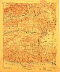
~ Camulos CA topo map, 1:125000 scale, 30 X 30 Minute, Historical, 1903, updated 1912
Camulos, California, USGS topographic map dated 1903.
Includes geographic coordinates (latitude and longitude). This topographic map is suitable for hiking, camping, and exploring, or framing it as a wall map.
Printed on-demand using high resolution imagery, on heavy weight and acid free paper, or alternatively on a variety of synthetic materials.
Topos available on paper, Waterproof, Poly, or Tyvek. Usually shipping rolled, unless combined with other folded maps in one order.
- Product Number: USGS-5505633
- Free digital map download (high-resolution, GeoPDF): Camulos, California (file size: 11 MB)
- Map Size: please refer to the dimensions of the GeoPDF map above
- Weight (paper map): ca. 55 grams
- Map Type: POD USGS Topographic Map
- Map Series: HTMC
- Map Verison: Historical
- Cell ID: 65114
- Scan ID: 299259
- Imprint Year: 1912
- Survey Year: 1901
- Datum: Unstated
- Map Projection: Unstated
- Map published by United States Geological Survey
- Map Language: English
- Scanner Resolution: 600 dpi
- Map Cell Name: Camulos
- Grid size: 30 X 30 Minute
- Date on map: 1903
- Map Scale: 1:125000
- Geographical region: California, United States
Neighboring Maps:
All neighboring USGS topo maps are available for sale online at a variety of scales.
Spatial coverage:
Topo map Camulos, California, covers the geographical area associated the following places:
- Leisure Village - Thousand Oaks - Santa Clarita - Sulphur Springs - Westlake Village - Lakeside Park - El Nido - Glenview - Cavin - Oak Hill - Wildwood - Greenwich Village - Pardee - Malibu Junction - Paradise Cove Mobile Home Park - Malibu Mar Vista (historical) - El Dorada Mobile Estates - Bouquet Junction - Runnymede Poultry Colony (historical) - Inceville - Lagol - Malibu Bowl - Winnetka - La Quinta - Brownstone (historical) - Agoura - Castaic - Ninetynine Oaks - Sherwood Forest - Malibu Vista - Castellammare - Oberg (historical) - Malibu West - Santa Susana Knolls - Castaic Junction - Hidden Hills - Trancas - Sylvia Park - North Ranch - Woodland Hills - Canoga Park - Oak Park - Cornell - Community Center - Tarzana - Seminole Springs Trailer Park - Encino - Malibu - Sespe Village - Piru - Newbury Park - Topanga Oaks - Somis - North Fillmore - Malibu Beach - Santa Susana - Oak Village - Moorpark - Mahou Riviera - Weeks Poultry Colony (historical) - Corriganville - Buckhorn - Bardsdale - Malibu Hills - Virginia Colony - Keith - Seminole Hot Springs - Fairview - Villa del Arroyo Mobile Home Estates - Riviera - Topanga Beach - Brents Junction - Northridge - Fern Ann Falls - Topanga Park - Chatsworth - Sespe - Casa Conejo - Conejo Valley Trailer Park - Moorpark Home Acres - Pico - Del Valle - Saugus - Agoura Hills - Ternez (historical) - Fillmore - Calabasas - Strathearn - Las Flores - Point Dume Mobile Home Park - Epworth - Deer Lake Highlands - Granada Hills - Fernwood - Friendly Village Mobile Home Park - Elayon - Simi Valley - Waltz - Solromar - Monte Nido
- Map Area ID: AREA34.534-119-118.5
- Northwest corner Lat/Long code: USGSNW34.5-119
- Northeast corner Lat/Long code: USGSNE34.5-118.5
- Southwest corner Lat/Long code: USGSSW34-119
- Southeast corner Lat/Long code: USGSSE34-118.5
- Northern map edge Latitude: 34.5
- Southern map edge Latitude: 34
- Western map edge Longitude: -119
- Eastern map edge Longitude: -118.5


