
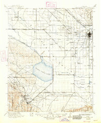
~ Buena Vista Lake CA topo map, 1:125000 scale, 30 X 30 Minute, Historical, 1912, updated 1947
Buena Vista Lake, California, USGS topographic map dated 1912.
Includes geographic coordinates (latitude and longitude). This topographic map is suitable for hiking, camping, and exploring, or framing it as a wall map.
Printed on-demand using high resolution imagery, on heavy weight and acid free paper, or alternatively on a variety of synthetic materials.
Topos available on paper, Waterproof, Poly, or Tyvek. Usually shipping rolled, unless combined with other folded maps in one order.
- Product Number: USGS-5505609
- Free digital map download (high-resolution, GeoPDF): Buena Vista Lake, California (file size: 6 MB)
- Map Size: please refer to the dimensions of the GeoPDF map above
- Weight (paper map): ca. 55 grams
- Map Type: POD USGS Topographic Map
- Map Series: HTMC
- Map Verison: Historical
- Cell ID: 65075
- Scan ID: 299247
- Imprint Year: 1947
- Survey Year: 1910
- Datum: NAD
- Map Projection: Polyconic
- Map published by United States Geological Survey
- Map Language: English
- Scanner Resolution: 600 dpi
- Map Cell Name: Buena Vista Lake
- Grid size: 30 X 30 Minute
- Date on map: 1912
- Map Scale: 1:125000
- Geographical region: California, United States
Neighboring Maps:
All neighboring USGS topo maps are available for sale online at a variety of scales.
Spatial coverage:
Topo map Buena Vista Lake, California, covers the geographical area associated the following places:
- Una - Stevens - Spellacy - Cawelo - Paloma (historical) - Calders Corner - Wible Orchard - Quailwood - Bannister - Gulf - Lerdo - Oildale - Oil Junction - Seguro - Saco - Hights Corner - Kyan (historical) - Bowerbank - Cherokee Strip - Conner - Buena Vista Mobile Home Park - Gosford - Fruitvale - Lakeview - Greenfield - Landco - Bakersfield - Thomas Lane - Millux - Strand (historical) - Alameda - Kilowatt - Hazelton - Venola - Crome - Buttonwillow - Prospero - Jastro - Maricopa - Mexican Colony - Tupman - Greenacres - South Taft - Old River - Smith Corner - Pentland - Ford City - Rio Bravo - San Emidio - Wallace Center - Pumpkin Center - Kern Lake - Panama - Taft Heights - Dustin Acres - Kern City - Valley Acres - Levee (historical) - Rosedale - Taft
- Map Area ID: AREA35.535-119.5-119
- Northwest corner Lat/Long code: USGSNW35.5-119.5
- Northeast corner Lat/Long code: USGSNE35.5-119
- Southwest corner Lat/Long code: USGSSW35-119.5
- Southeast corner Lat/Long code: USGSSE35-119
- Northern map edge Latitude: 35.5
- Southern map edge Latitude: 35
- Western map edge Longitude: -119.5
- Eastern map edge Longitude: -119


