
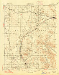
~ Barstow CA topo map, 1:125000 scale, 30 X 30 Minute, Historical, 1934, updated 1948
Barstow, California, USGS topographic map dated 1934.
Includes geographic coordinates (latitude and longitude). This topographic map is suitable for hiking, camping, and exploring, or framing it as a wall map.
Printed on-demand using high resolution imagery, on heavy weight and acid free paper, or alternatively on a variety of synthetic materials.
Topos available on paper, Waterproof, Poly, or Tyvek. Usually shipping rolled, unless combined with other folded maps in one order.
- Product Number: USGS-5505517
- Free digital map download (high-resolution, GeoPDF): Barstow, California (file size: 7 MB)
- Map Size: please refer to the dimensions of the GeoPDF map above
- Weight (paper map): ca. 55 grams
- Map Type: POD USGS Topographic Map
- Map Series: HTMC
- Map Verison: Historical
- Cell ID: 64950
- Scan ID: 299201
- Imprint Year: 1948
- Survey Year: 1932
- Datum: NAD27
- Map Projection: Polyconic
- Map published by United States Geological Survey
- Map Language: English
- Scanner Resolution: 600 dpi
- Map Cell Name: Barstow
- Grid size: 30 X 30 Minute
- Date on map: 1934
- Map Scale: 1:125000
- Geographical region: California, United States
Neighboring Maps:
All neighboring USGS topo maps are available for sale online at a variety of scales.
Spatial coverage:
Topo map Barstow, California, covers the geographical area associated the following places:
- Frost - Greentree East - The Village - Adelanto - Barstow Heights - Silver Lakes - Mountain View - Oro Grande - Thunderbird Ranches - Hutt - Desert Knolls - Hawes (historical) - Desert Knolls Manor - Bell Mountain - Victorville - Lenwood - Wild Crossing - Helendale - Mace (historical) - Apple Valley - Jimgrey - Bryman - Mojave Heights - Bellevue Heights - Skyline North - Leon - La Delta - Hodge - Irwin Estates - Golden Mesa - South Adelanto - Valley High North - Kramer Hills (historical) - Barstow - Grandview - Johnstons Corner - Eads (historical) - Hinkley - North Barstow
- Map Area ID: AREA3534.5-117.5-117
- Northwest corner Lat/Long code: USGSNW35-117.5
- Northeast corner Lat/Long code: USGSNE35-117
- Southwest corner Lat/Long code: USGSSW34.5-117.5
- Southeast corner Lat/Long code: USGSSE34.5-117
- Northern map edge Latitude: 35
- Southern map edge Latitude: 34.5
- Western map edge Longitude: -117.5
- Eastern map edge Longitude: -117


