
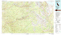
~ Yosemite Valley CA topo map, 1:100000 scale, 30 X 60 Minute, Historical, 1976, updated 1994
Yosemite Valley, California, USGS topographic map dated 1976.
Includes geographic coordinates (latitude and longitude). This topographic map is suitable for hiking, camping, and exploring, or framing it as a wall map.
Printed on-demand using high resolution imagery, on heavy weight and acid free paper, or alternatively on a variety of synthetic materials.
Topos available on paper, Waterproof, Poly, or Tyvek. Usually shipping rolled, unless combined with other folded maps in one order.
- Product Number: USGS-5505505
- Free digital map download (high-resolution, GeoPDF): Yosemite Valley, California (file size: 32 MB)
- Map Size: please refer to the dimensions of the GeoPDF map above
- Weight (paper map): ca. 55 grams
- Map Type: POD USGS Topographic Map
- Map Series: HTMC
- Map Verison: Historical
- Cell ID: 68627
- Scan ID: 299193
- Imprint Year: 1994
- Woodland Tint: Yes
- Visual Version Number: 2
- Photo Inspection Year: 1988
- Aerial Photo Year: 1973
- Edit Year: 1976
- Datum: NAD27
- Map Projection: Universal Transverse Mercator
- Map published by United States Geological Survey
- Map Language: English
- Scanner Resolution: 600 dpi
- Map Cell Name: Yosemite Valley
- Grid size: 30 X 60 Minute
- Date on map: 1976
- Map Scale: 1:100000
- Geographical region: California, United States
Neighboring Maps:
All neighboring USGS topo maps are available for sale online at a variety of scales.
Spatial coverage:
Topo map Yosemite Valley, California, covers the geographical area associated the following places:
- Lee Vining - Bennettville (historical) - Sequoia - Darrah - Aspen Valley - South Wawona - White Wolf - Briceburg - South Wawona (historical) - El Portal - North Wawona (historical) - Hite Cove - Yosemite Village - Harden Flat - Midpines - Mather - Yosemite West - Wawona - Incline - Curry Village - Foresta - Clearing House - Buena Vista - Jerseydale - North Wawona - June Lake Junction - June Lake - Lake Mary
- Map Area ID: AREA3837.5-120-119
- Northwest corner Lat/Long code: USGSNW38-120
- Northeast corner Lat/Long code: USGSNE38-119
- Southwest corner Lat/Long code: USGSSW37.5-120
- Southeast corner Lat/Long code: USGSSE37.5-119
- Northern map edge Latitude: 38
- Southern map edge Latitude: 37.5
- Western map edge Longitude: -120
- Eastern map edge Longitude: -119


