
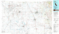
~ Visalia CA topo map, 1:100000 scale, 30 X 60 Minute, Historical, 1993, updated 1993
Visalia, California, USGS topographic map dated 1993.
Includes geographic coordinates (latitude and longitude). This topographic map is suitable for hiking, camping, and exploring, or framing it as a wall map.
Printed on-demand using high resolution imagery, on heavy weight and acid free paper, or alternatively on a variety of synthetic materials.
Topos available on paper, Waterproof, Poly, or Tyvek. Usually shipping rolled, unless combined with other folded maps in one order.
- Product Number: USGS-5505499
- Free digital map download (high-resolution, GeoPDF): Visalia, California (file size: 21 MB)
- Map Size: please refer to the dimensions of the GeoPDF map above
- Weight (paper map): ca. 55 grams
- Map Type: POD USGS Topographic Map
- Map Series: HTMC
- Map Verison: Historical
- Cell ID: 68530
- Scan ID: 299190
- Imprint Year: 1993
- Woodland Tint: Yes
- Visual Version Number: 2
- Aerial Photo Year: 1984
- Edit Year: 1993
- Datum: NAD27
- Map Projection: Universal Transverse Mercator
- Map published by United States Geological Survey
- Map Language: English
- Scanner Resolution: 600 dpi
- Map Cell Name: Visalia
- Grid size: 30 X 60 Minute
- Date on map: 1993
- Map Scale: 1:100000
- Geographical region: California, United States
Neighboring Maps:
All neighboring USGS topo maps are available for sale online at a variety of scales.
Spatial coverage:
Topo map Visalia, California, covers the geographical area associated the following places:
- Hasset (historical) - Yokohl - Lois - Gillete - Chinowths Corner - Kimble (historical) - Fort Roosevelt - Lemoncove - Grangeville - Stout - Toolville - Reynolds (historical) - Rayo - Tulare - Burling (historical) - Gepford - Odessa (historical) - Goshen - Taurusa - Cameron Creek Colony - Riverdale - Sandspur (historical) - Lort - Camden - Rossi - Westfield - Bean (historical) - Kings Mobile Home Estates - Roche - Fayette - Hanford Del Arroyo Estates - Orlem (historical) - Redbanks - Schilling - Hanford - London - Porterville - Imhoff - Lisko - Shirley - Yettem - Midvalley - Armona - Home Garden - Stratford - Calgro - Four Seasons Mobile And Recreational Vehicle Park - Cimarron - Harmony - Tonyville - Sierra Heights - Nanceville - Lethent (historical) - Lindsay - Kingston (historical) - Millham City (historical) - Sierra Vista Mobile Estates - Mitchell Corner - Robinson (historical) - Naranjo - Burr - Sides (historical) - Cairns Corner - Venida - Saint Johns - Merryman - Waukena - Monson - Vincent - Lowes Corner - Tiffin (historical) - Prewit (historical) - Vance - Exeter - Matchin - Kettleman City - Visalia - Tagus - Hardwick - Lemoore - Lanare - Lillis (historical) - Loma - Sequoia - Burrel - Fane - Higby - Cotton Center - Orion (historical) - Strathmore - Bel Air Mobile Home Park - Rector - Rocky Hill - Traver - Remnoy - Citro - Zante - Lindcove - Hope (historical) - El Dorado Mobile Home Park
- Map Area ID: AREA36.536-120-119
- Northwest corner Lat/Long code: USGSNW36.5-120
- Northeast corner Lat/Long code: USGSNE36.5-119
- Southwest corner Lat/Long code: USGSSW36-120
- Southeast corner Lat/Long code: USGSSE36-119
- Northern map edge Latitude: 36.5
- Southern map edge Latitude: 36
- Western map edge Longitude: -120
- Eastern map edge Longitude: -119


