
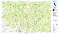
~ Shaver Lake CA topo map, 1:100000 scale, 30 X 60 Minute, Historical, 1980, updated 1991
Shaver Lake, California, USGS topographic map dated 1980.
Includes geographic coordinates (latitude and longitude). This topographic map is suitable for hiking, camping, and exploring, or framing it as a wall map.
Printed on-demand using high resolution imagery, on heavy weight and acid free paper, or alternatively on a variety of synthetic materials.
Topos available on paper, Waterproof, Poly, or Tyvek. Usually shipping rolled, unless combined with other folded maps in one order.
- Product Number: USGS-5505455
- Free digital map download (high-resolution, GeoPDF): Shaver Lake, California (file size: 30 MB)
- Map Size: please refer to the dimensions of the GeoPDF map above
- Weight (paper map): ca. 55 grams
- Map Type: POD USGS Topographic Map
- Map Series: HTMC
- Map Verison: Historical
- Cell ID: 68351
- Scan ID: 299177
- Imprint Year: 1991
- Woodland Tint: Yes
- Aerial Photo Year: 1975
- Edit Year: 1980
- Datum: NAD27
- Map Projection: Universal Transverse Mercator
- Map published by United States Geological Survey
- Map Language: English
- Scanner Resolution: 600 dpi
- Map Cell Name: Shaver Lake
- Grid size: 30 X 60 Minute
- Date on map: 1980
- Map Scale: 1:100000
- Geographical region: California, United States
Neighboring Maps:
All neighboring USGS topo maps are available for sale online at a variety of scales.
Spatial coverage:
Topo map Shaver Lake, California, covers the geographical area associated the following places:
- Yosemite Lakes - Huntington Lake - Alder Springs - Willow Glen (historical) - Lakeshore - Fish Camp - Knowles - Oakhurst - Ahwahnee Estates - Shaver Lake - Pineridge - Bass Lake Annex - Fresno Crossing - Yosemite Lakes Park - Indian Springs - Sugar Pine - Bass Lake - Nipinnawasee - Prather - Whisky Falls - Old Corral - Sierra Cedars - Grub Gulch (historical) - Dinkey Creek - Shaver Lake Heights - Knowles Junction - Bretz Mill - Coarsegold - Hillside (historical) - Auberry - South Fork - Cascadel Woods - Mormon Bar - Raymond - North Fork - Old Bretz Mill - Magnet (historical) - The Pines - Mathews Mill - Cedar Crest - Marshall Junction - Camp Sierra - Tollhouse - Elliott Corner - New Auberry - Lerona - Meadow Lakes - Fine Gold - Narbo (historical) - Ponderosa Basin - Rock Haven - Bailey Flats (historical) - Big Creek - Bootjack - Yosemite Forks - Jesbel (historical) - Ockenden - Mono Hot Springs - Daulton - Central Camp - Lake Madera Country Estates - Indian Lakes Estates - O'Neals - Dora Belle - Mariposa - Fort Miller (historical) - Ben Hur - Hildreth - Ahwahnee - Snow Bend
- Map Area ID: AREA37.537-120-119
- Northwest corner Lat/Long code: USGSNW37.5-120
- Northeast corner Lat/Long code: USGSNE37.5-119
- Southwest corner Lat/Long code: USGSSW37-120
- Southeast corner Lat/Long code: USGSSE37-119
- Northern map edge Latitude: 37.5
- Southern map edge Latitude: 37
- Western map edge Longitude: -120
- Eastern map edge Longitude: -119


