
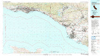
~ Santa Barbara CA topo map, 1:100000 scale, 30 X 60 Minute, Historical, 1982, updated 1992
Santa Barbara, California, USGS topographic map dated 1982.
Includes geographic coordinates (latitude and longitude). This topographic map is suitable for hiking, camping, and exploring, or framing it as a wall map.
Printed on-demand using high resolution imagery, on heavy weight and acid free paper, or alternatively on a variety of synthetic materials.
Topos available on paper, Waterproof, Poly, or Tyvek. Usually shipping rolled, unless combined with other folded maps in one order.
- Product Number: USGS-5505441
- Free digital map download (high-resolution, GeoPDF): Santa Barbara, California (file size: 30 MB)
- Map Size: please refer to the dimensions of the GeoPDF map above
- Weight (paper map): ca. 55 grams
- Map Type: POD USGS Topographic Map
- Map Series: HTMC
- Map Verison: Historical
- Cell ID: 68319
- Scan ID: 299173
- Imprint Year: 1992
- Woodland Tint: Yes
- Aerial Photo Year: 1978
- Edit Year: 1982
- Datum: NAD27
- Map Projection: Universal Transverse Mercator
- Map published by United States Geological Survey
- Map Language: English
- Scanner Resolution: 600 dpi
- Map Cell Name: Santa Barbara
- Grid size: 30 X 60 Minute
- Date on map: 1982
- Map Scale: 1:100000
- Geographical region: California, United States
Neighboring Maps:
All neighboring USGS topo maps are available for sale online at a variety of scales.
Spatial coverage:
Topo map Santa Barbara, California, covers the geographical area associated the following places:
- Golden Oaks Mobile Estates - Shepards - Hope Ranch - Summerland - Serena Park - Spanish Hills - Vista de Santa Barbara Mobile Homes - Nyland - Arbolada - Limon - Matilija - Casitas Springs - Goleta - Faria - Channel Islands Beach - Old Town - Ojai - Camp Bartlett - Matilija Springs - Mission - Santa Paula - Sea Cliff - Del Francia Mobile Estates - Sandyland Cove - Royal Palms Mobile Home Park - Somis (historical) - Rancho Granada Mobile Homes - Oxnard Shores - Kimballville (historical) - Ortega - Oxnard - Rancho Santa Paul Mobile Home Park - Silver Strand - Strickland Acres - Carpinteria - Irma - Santa Barbara - El Sueno - El Encano Heights - Pierpont Bay - Howell Place - Isla Vista - Mishopshnow (historical) - Leesdale - Springville - La Patera - Miscanaka (historical) - Ventura - Sandyland - Vickers Hot Springs - Pleasant Valley Mobile Home Park - Old Town - Teagueville (historical) - Kimball - Los Pitos (historical) - Franciscan Village - Ellwood - Toro Canyon - Haines - Arts Trailer Court - Dulah - Owl Mobile Manor - Arroyo Mobile Home Park - Kevet - Chrisman - Sycamore Cove - El Sereno Estates Mobile Home Park - Wadstrom - Saticoy - Montecito - Mira Monte - Golden Oaks Mobile Home Park - West Saticoy - Limoneira - Oak View - Hollywood Beach - Orchams - San Roque Mobile Home - Mission Canyon - Naples - Rancho Adolfo Mobile Home Estates - Live Oak Acres - Serena - Ortonville - Meiners Oaks Trailer Park - Meiners Oaks - Montalvo - Wene'me (historical) - Lamplighter Mobile Home Park - Casa del Norte Mobile Home Community - Port Hueneme - Camarillo Mobile Estates - Ojala - El Rio - Mussel Shoals - Sucrosa (historical) - The Colony Mobile Home Park - Rincon - Weldons - Sandpiper Mobile Home Park
- Map Area ID: AREA34.534-120-119
- Northwest corner Lat/Long code: USGSNW34.5-120
- Northeast corner Lat/Long code: USGSNE34.5-119
- Southwest corner Lat/Long code: USGSSW34-120
- Southeast corner Lat/Long code: USGSSE34-119
- Northern map edge Latitude: 34.5
- Southern map edge Latitude: 34
- Western map edge Longitude: -120
- Eastern map edge Longitude: -119


