
~ San Diego CA topo map, 1:100000 scale, 30 X 60 Minute, Historical, 1979, updated 1988
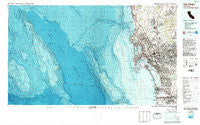
San Diego, California, USGS topographic map dated 1979.
Includes geographic coordinates (latitude and longitude). This topographic map is suitable for hiking, camping, and exploring, or framing it as a wall map.
Printed on-demand using high resolution imagery, on heavy weight and acid free paper, or alternatively on a variety of synthetic materials.
Topos available on paper, Waterproof, Poly, or Tyvek. Usually shipping rolled, unless combined with other folded maps in one order.
- Product Number: USGS-5505427
- Free digital map download (high-resolution, GeoPDF): San Diego, California (file size: 47 MB)
- Map Size: please refer to the dimensions of the GeoPDF map above
- Weight (paper map): ca. 55 grams
- Map Type: POD USGS Topographic Map
- Map Series: HTMC
- Map Verison: Historical
- Cell ID: 68304
- Scan ID: 299168
- Imprint Year: 1988
- Woodland Tint: Yes
- Visual Version Number: 2
- Aerial Photo Year: 1977
- Edit Year: 1979
- Datum: NAD27
- Map Projection: Universal Transverse Mercator
- Map published by United States Geological Survey
- Map Language: English
- Scanner Resolution: 600 dpi
- Map Cell Name: San Diego
- Grid size: 30 X 60 Minute
- Date on map: 1979
- Map Scale: 1:100000
- Geographical region: California, United States
Neighboring Maps:
All neighboring USGS topo maps are available for sale online at a variety of scales.
Spatial coverage:
Topo map San Diego, California, covers the geographical area associated the following places:
- Solana Beach - Logan Heights - Campland on the Bay Trailer Park - Eden Gardens - Valencia Park - Del Mar - Sherman Heights - Poway - Shelltown - Palm City - La Jolla - Coronado - Poway Grove Park - Emerald Hills - Miramar - Barrio Logan - Village Green Trailer Park - Sorrento - Clairemont - South Park - Linda Vista (historical) - Sunnyside - Tent City (historical) - Selwyn (historical) - South San Diego - San Ysidro - The Woods Trailer Park - Pacific Beach - Nestor - Pleasant Valley Mobile Home Park - Sunset Cliffs - Fruitdale - Riviera Villas - Tierrasanta - South Crest - Lomita - Rancho Penasquitos - Otay Mesa - Mission Beach - Roseville - Lynwood Hills - Overlook - Mission Gorge Villa Mobile Home Park - Poway Grove (historical) - Highlands Mobile Home Park - Brooklyn Heights - Bayside Village - Del Cerro - Morena - Ocean Beach - Easter Cross - Mission Hills - Chollas View - Normal Heights - Lemon Grove - Sabre Springs - Mount Hope - The Muirlands - South Bay Terraces - South Encantato - De Anza Trailer Harbor - Sunny Vista - North Bay Terraces - Serra Mesa - La Mesa - Allied Gardens - Mira Mesa - Stockton - North Park - Harbor Side - Imperial Beach - University Heights - Mountain View - Loma Portal - La Playa - Boal - Riviera Shores - Ladrillo (historical) - Haleys Trailer Ranch - Hillcrest - Elvira - La Jolla Shores - Lincoln Acres - Poway Royal Mobile Estates - Lincoln Park - La Jolla Hermosa - Scripps Ranch - Rancho del Rey - Five Points - Old Town San Diego - Bonita - Fort Rosecrans - Greenbrier Mobile Home Park - Fleetridge - Grantville - Del Mar Heights - North Clairemont - Chollas Creek - Castle Park - Bay Park
- Map Area ID: AREA3332.5-118-117
- Northwest corner Lat/Long code: USGSNW33-118
- Northeast corner Lat/Long code: USGSNE33-117
- Southwest corner Lat/Long code: USGSSW32.5-118
- Southeast corner Lat/Long code: USGSSE32.5-117
- Northern map edge Latitude: 33
- Southern map edge Latitude: 32.5
- Western map edge Longitude: -118
- Eastern map edge Longitude: -117


