
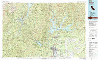
~ Redding CA topo map, 1:100000 scale, 30 X 60 Minute, Historical, 1984, updated 1984
Redding, California, USGS topographic map dated 1984.
Includes geographic coordinates (latitude and longitude). This topographic map is suitable for hiking, camping, and exploring, or framing it as a wall map.
Printed on-demand using high resolution imagery, on heavy weight and acid free paper, or alternatively on a variety of synthetic materials.
Topos available on paper, Waterproof, Poly, or Tyvek. Usually shipping rolled, unless combined with other folded maps in one order.
- Product Number: USGS-5505399
- Free digital map download (high-resolution, GeoPDF): Redding, California (file size: 36 MB)
- Map Size: please refer to the dimensions of the GeoPDF map above
- Weight (paper map): ca. 55 grams
- Map Type: POD USGS Topographic Map
- Map Series: HTMC
- Map Verison: Historical
- Cell ID: 68220
- Scan ID: 299154
- Imprint Year: 1984
- Woodland Tint: Yes
- Aerial Photo Year: 1978
- Edit Year: 1984
- Datum: NAD27
- Map Projection: Universal Transverse Mercator
- Map published by United States Geological Survey
- Map Language: English
- Scanner Resolution: 600 dpi
- Map Cell Name: Redding
- Grid size: 30 X 60 Minute
- Date on map: 1984
- Map Scale: 1:100000
- Geographical region: California, United States
Neighboring Maps:
All neighboring USGS topo maps are available for sale online at a variety of scales.
Spatial coverage:
Topo map Redding, California, covers the geographical area associated the following places:
- Los Robles Estates - Douglas City - Kett - Redding Lakeside Mobile Estates - Country Aire Mobile Home Park - Calkins (historical) - Ellis (historical) - Project City (historical) - Redwoods Mobile Home Community - Quartz Point Mobile Home Park - Millville - Trinity Alps - Enterprise Mobile Park - Deadwood - Government Camp - Coram - Paige Bar - Frazier Corners - Baird (historical) - Moose-horn Mobile Home Park - Marina Travel Park - Portal Inn - Houston (historical) - Churntown (historical) - Sugarloaf - Keno (historical) - Twin View Terrace Mobile Home Park - Kelly (historical) - Ingot - Vollmers - Country Club Mobile Estates - Whiskeytown - Safari Mobile Home Park - Shasta - McColl - Ridgeville - Bayha (historical) - Oak Run - Fitzpatrick (historical) - Whitehouse (historical) - Igo - Wonderland Mobile Home Park - Mabel (historical) - Clear Creek Mobile Home Park - Winthrop (historical) - Keswick Dam Trailer Park - O'Brien - Holiday Harbor Resort - Point McCloud - Shasta Lake - Redding Oaks Mobile Home Park - Antlers - Bucktail - Silverthorn - Iron Mountain - Keswick - Hogtown (historical) - Pollard Flat - Pine Grove - Elmore (historical) - Palo Cedro - Minersville (historical) - Summit City (historical) - Middletown (historical) - Bully Hill - Sherman - Redding - Lakeshore - Girvan - Shady Acres Trailer Park - Morley (historical) - Lewiston - Fairview - Matheson - Brookside Mobile Home Park - Oak Bottom (historical) - Loomis Corners - Henryford (historical) - Hart (historical) - Paradise View Mobile Estates - Wagoner - Waugh (historical) - Wilkinson - French Gulch - Shasta Lake Mobile Home Park - Estrellita - Lillienthal (historical) - Newtown - Centerville - Kennett (historical) - Northgate Trailer Park - Pinewood Cove - Mountain Shadows Mobile Home Estates - Tunnel Inn - Minnesota - Starlite Mobile Estates - Pacheco - Lakehead - Lakeview Resort - Twin Lakes Mobile Estates
- Map Area ID: AREA4140.5-123-122
- Northwest corner Lat/Long code: USGSNW41-123
- Northeast corner Lat/Long code: USGSNE41-122
- Southwest corner Lat/Long code: USGSSW40.5-123
- Southeast corner Lat/Long code: USGSSE40.5-122
- Northern map edge Latitude: 41
- Southern map edge Latitude: 40.5
- Western map edge Longitude: -123
- Eastern map edge Longitude: -122


