
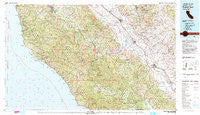
~ Point Sur CA topo map, 1:100000 scale, 30 X 60 Minute, Historical, 1982, updated 1980
Point Sur, California, USGS topographic map dated 1982.
Includes geographic coordinates (latitude and longitude). This topographic map is suitable for hiking, camping, and exploring, or framing it as a wall map.
Printed on-demand using high resolution imagery, on heavy weight and acid free paper, or alternatively on a variety of synthetic materials.
Topos available on paper, Waterproof, Poly, or Tyvek. Usually shipping rolled, unless combined with other folded maps in one order.
- Product Number: USGS-5505389
- Free digital map download (high-resolution, GeoPDF): Point Sur, California (file size: 36 MB)
- Map Size: please refer to the dimensions of the GeoPDF map above
- Weight (paper map): ca. 55 grams
- Map Type: POD USGS Topographic Map
- Map Series: HTMC
- Map Verison: Historical
- Cell ID: 68168
- Scan ID: 299148
- Imprint Year: 1980
- Woodland Tint: Yes
- Aerial Photo Year: 1978
- Edit Year: 1982
- Datum: NAD27
- Map Projection: Universal Transverse Mercator
- Map Language: English
- Scanner Resolution: 600 dpi
- Map Cell Name: Point Sur
- Grid size: 30 X 60 Minute
- Date on map: 1982
- Map Scale: 1:100000
- Geographical region: California, United States
Neighboring Maps:
All neighboring USGS topo maps are available for sale online at a variety of scales.
Spatial coverage:
Topo map Point Sur, California, covers the geographical area associated the following places:
- Greenfield - Mascorini Place - Camphora - Lucia - Welby - Jamesburg - Hunter-Liggett - Big Sur - Robles Del Rio - Soledad - Grove Mobile Home Park - Posts - Rio Plaza Mobile Home Park - Carmel Valley - Tassajara Hot Springs - Coburn - San Lucas - Bitterwater - Slates Hot Springs - Harlem - Carmel Valley Village - Sycamore Flat - Metz - Pine Canyon Mobile Estates - Elsa - Fort Romie - Notleys Landing - Molus - King City - Millers Ranch
- Map Area ID: AREA36.536-122-121
- Northwest corner Lat/Long code: USGSNW36.5-122
- Northeast corner Lat/Long code: USGSNE36.5-121
- Southwest corner Lat/Long code: USGSSW36-122
- Southeast corner Lat/Long code: USGSSE36-121
- Northern map edge Latitude: 36.5
- Southern map edge Latitude: 36
- Western map edge Longitude: -122
- Eastern map edge Longitude: -121


