
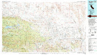
~ Big Bear Lake CA topo map, 1:100000 scale, 30 X 60 Minute, Historical, 1982, updated 1996
Big Bear Lake, California, USGS topographic map dated 1982.
Includes geographic coordinates (latitude and longitude). This topographic map is suitable for hiking, camping, and exploring, or framing it as a wall map.
Printed on-demand using high resolution imagery, on heavy weight and acid free paper, or alternatively on a variety of synthetic materials.
Topos available on paper, Waterproof, Poly, or Tyvek. Usually shipping rolled, unless combined with other folded maps in one order.
- Product Number: USGS-5505207
- Free digital map download (high-resolution, GeoPDF): Big Bear Lake, California (file size: 30 MB)
- Map Size: please refer to the dimensions of the GeoPDF map above
- Weight (paper map): ca. 55 grams
- Map Type: POD USGS Topographic Map
- Map Series: HTMC
- Map Verison: Historical
- Cell ID: 67130
- Scan ID: 299050
- Imprint Year: 1996
- Woodland Tint: Yes
- Aerial Photo Year: 1979
- Edit Year: 1982
- Datum: NAD27
- Map Projection: Universal Transverse Mercator
- Map published by United States Geological Survey
- Map published by United States Forest Service
- Map Language: English
- Scanner Resolution: 600 dpi
- Map Cell Name: Big Bear Lake
- Grid size: 30 X 60 Minute
- Date on map: 1982
- Map Scale: 1:100000
- Geographical region: California, United States
Neighboring Maps:
All neighboring USGS topo maps are available for sale online at a variety of scales.
Spatial coverage:
Topo map Big Bear Lake, California, covers the geographical area associated the following places:
- Lucerne Valley - Forest Falls - Smoke Tree - Seven Oaks - Oak Glen - Rimrock - Sunfair Heights - Hidden River - Moonridge - Pinto Wye - Mountain Home Village - Minnelusa - Boulder Bay - Big Bear Lake - Angelus Oaks - Doble - Landers - The Plaza - Yucca Valley - Palm Wells - Pioneertown - Woodlands - Harmony Acres - Joshua Tree - Pinezanita - Panorama Heights - Sugarloaf - The Pines (historical) - Little Morongo Heights - Baldwin Lake - Cushenbury - Fawnskin - Flamingo Heights - Sunfair - Morongo Valley - Glen Martin - Big Bear City - Twentynine Palms - Desert Heights - Heart Bar Campground
- Map Area ID: AREA34.534-117-116
- Northwest corner Lat/Long code: USGSNW34.5-117
- Northeast corner Lat/Long code: USGSNE34.5-116
- Southwest corner Lat/Long code: USGSSW34-117
- Southeast corner Lat/Long code: USGSSE34-116
- Northern map edge Latitude: 34.5
- Southern map edge Latitude: 34
- Western map edge Longitude: -117
- Eastern map edge Longitude: -116


