
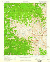
~ Triple Divide Peak CA topo map, 1:62500 scale, 15 X 15 Minute, Historical, 1956, updated 1960
Triple Divide Peak, California, USGS topographic map dated 1956.
Includes geographic coordinates (latitude and longitude). This topographic map is suitable for hiking, camping, and exploring, or framing it as a wall map.
Printed on-demand using high resolution imagery, on heavy weight and acid free paper, or alternatively on a variety of synthetic materials.
Topos available on paper, Waterproof, Poly, or Tyvek. Usually shipping rolled, unless combined with other folded maps in one order.
- Product Number: USGS-5504843
- Free digital map download (high-resolution, GeoPDF): Triple Divide Peak, California (file size: 11 MB)
- Map Size: please refer to the dimensions of the GeoPDF map above
- Weight (paper map): ca. 55 grams
- Map Type: POD USGS Topographic Map
- Map Series: HTMC
- Map Verison: Historical
- Cell ID: 63701
- Scan ID: 301857
- Imprint Year: 1960
- Woodland Tint: Yes
- Aerial Photo Year: 1955
- Field Check Year: 1956
- Datum: NAD27
- Map Projection: Polyconic
- Map published by United States Geological Survey
- Map Language: English
- Scanner Resolution: 600 dpi
- Map Cell Name: Triple Divide Peak
- Grid size: 15 X 15 Minute
- Date on map: 1956
- Map Scale: 1:62500
- Geographical region: California, United States
Neighboring Maps:
All neighboring USGS topo maps are available for sale online at a variety of scales.
Spatial coverage:
Topo map Triple Divide Peak, California, covers the geographical area associated the following places:
- Sugarloaf Meadow - Little Lake - Scaffold Meadows - Roaring River Ranger Station - Tharps Log - Redwood Meadow - Ball Dome - Aster Lake - Cloud Canyon - Elizabeth Pass - Sugarloaf Valley - Beville Lake - Big Brewer Lake - Mount Silliman - Lost Lake - Silliman Crest - Emerald Lake - Talus Lake - Buck Canyon - Cross Mountain - Log Bridge Campground - Big Wet Meadow - Kettle Peak - Silliman Pass - Marvin Pass - Barton Creek - Moraine Meadows - Old Big Arroyo Patrol Cabin - Avalanche Pass - Willow Meadow - Moro Creek - Crescent Meadow - Moose Lake - Josephine Lake - Twin Lakes - Sheep Camp Lakes - Crowley Canyon - High Sierra Trail - Valhalla - Table Meadows - Precipice Lake - Cahoon Gap - Redwood Meadows Ranger Station - Little Five Lakes - Mount Maddox - Palmer Mountain - Black Kaweah - Nine Lake Basin - East Fork Clover Creek - River Valley - South Fork Sugarloaf Creek - Bearpaw Meadow Ranger Station - Brewer Creek - Panoramic View (historical) - Deadman Canyon - Lodgepole Ranger Station - Colby Pass - Ranger Meadow - Castle Creek - Lackeys Cabin - Profile View - Tharps Rock - Twin Peaks - Panther Peak - Long Meadow - Alta Peak - Lone Pine Meadow - Barton Peak - Colby Lake - Whaleback - Eagle View - Glacier Ridge - Copper Mine Pass - Mount Stewart - Cunningham Creek - Mehrten Meadow - Triple Divide Pass - Lippincott Mountain - Pearl Lake Ranger Station - Box Canyon - Big Bird Lake - Congress Group - Panther Creek - Seville Lake - Kings-Kaweah Divide - Mitchell Peak - Hamilton Lakes - Table Creek - Buck Creek - Kaweah Gap - Kaweah Queen - Pear Lake - Lone Pine Creek - Moraine Ridge - Lodgepole - Eagle Scout Creek - Rowell Meadow - Mehrten Creek - Cement Table Meadow - Lawson Peak
- Map Area ID: AREA36.7536.5-118.75-118.5
- Northwest corner Lat/Long code: USGSNW36.75-118.75
- Northeast corner Lat/Long code: USGSNE36.75-118.5
- Southwest corner Lat/Long code: USGSSW36.5-118.75
- Southeast corner Lat/Long code: USGSSE36.5-118.5
- Northern map edge Latitude: 36.75
- Southern map edge Latitude: 36.5
- Western map edge Longitude: -118.75
- Eastern map edge Longitude: -118.5


