
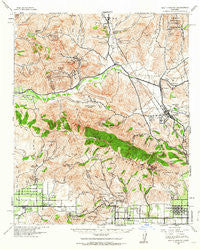
~ Santa Susana CA topo map, 1:62500 scale, 15 X 15 Minute, Historical, 1941, updated 1964
Santa Susana, California, USGS topographic map dated 1941.
Includes geographic coordinates (latitude and longitude). This topographic map is suitable for hiking, camping, and exploring, or framing it as a wall map.
Printed on-demand using high resolution imagery, on heavy weight and acid free paper, or alternatively on a variety of synthetic materials.
Topos available on paper, Waterproof, Poly, or Tyvek. Usually shipping rolled, unless combined with other folded maps in one order.
- Product Number: USGS-5504379
- Free digital map download (high-resolution, GeoPDF): Santa Susana, California (file size: 11 MB)
- Map Size: please refer to the dimensions of the GeoPDF map above
- Weight (paper map): ca. 55 grams
- Map Type: POD USGS Topographic Map
- Map Series: HTMC
- Map Verison: Historical
- Cell ID: 62140
- Scan ID: 301632
- Imprint Year: 1964
- Woodland Tint: Yes
- Aerial Photo Year: 1938
- Survey Year: 1900
- Datum: NAD27
- Map Projection: Polyconic
- Map published by United States Army Corps of Engineers
- Map published by United States Department of War
- Map Language: English
- Scanner Resolution: 600 dpi
- Map Cell Name: Santa Susana
- Grid size: 15 X 15 Minute
- Date on map: 1941
- Map Scale: 1:62500
- Geographical region: California, United States
Neighboring Maps:
All neighboring USGS topo maps are available for sale online at a variety of scales.
Spatial coverage:
Topo map Santa Susana, California, covers the geographical area associated the following places:
- Twin Lakes - Saugus - Santa Clarita - Waltz - Pardee - Elayon - Castaic Junction - Sulphur Springs - Newhall - Rancho Santa Clarita - Santa Susana - Santa Susana Knolls - Fern Ann Falls - Granada Hills - Deer Lake Highlands - Bouquet Junction - Valencia - Oberg (historical) - Community Center - Castaic - Ninetynine Oaks - Pico - La Quinta - Corriganville - Del Valle - Chatsworth - Val Verde
- Map Area ID: AREA34.534.25-118.75-118.5
- Northwest corner Lat/Long code: USGSNW34.5-118.75
- Northeast corner Lat/Long code: USGSNE34.5-118.5
- Southwest corner Lat/Long code: USGSSW34.25-118.75
- Southeast corner Lat/Long code: USGSSE34.25-118.5
- Northern map edge Latitude: 34.5
- Southern map edge Latitude: 34.25
- Western map edge Longitude: -118.75
- Eastern map edge Longitude: -118.5


