
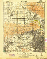
~ Santa Monica CA topo map, 1:62500 scale, 15 X 15 Minute, Historical, 1921, updated 1921
Santa Monica, California, USGS topographic map dated 1921.
Includes geographic coordinates (latitude and longitude). This topographic map is suitable for hiking, camping, and exploring, or framing it as a wall map.
Printed on-demand using high resolution imagery, on heavy weight and acid free paper, or alternatively on a variety of synthetic materials.
Topos available on paper, Waterproof, Poly, or Tyvek. Usually shipping rolled, unless combined with other folded maps in one order.
- Product Number: USGS-5504333
- Free digital map download (high-resolution, GeoPDF): Santa Monica, California (file size: 10 MB)
- Map Size: please refer to the dimensions of the GeoPDF map above
- Weight (paper map): ca. 55 grams
- Map Type: POD USGS Topographic Map
- Map Series: HTMC
- Map Verison: Historical
- Cell ID: 62134
- Scan ID: 298954
- Imprint Year: 1921
- Woodland Tint: Yes
- Visual Version Number: 2
- Aerial Photo Year: 1919
- Edit Year: 1920
- Datum: Unstated
- Map Projection: Unstated
- Map published by United States Army Corps of Engineers
- Map published by: Military, Other
- Map Language: English
- Scanner Resolution: 600 dpi
- Map Cell Name: Santa Monica
- Grid size: 15 X 15 Minute
- Date on map: 1921
- Map Scale: 1:62500
- Geographical region: California, United States
Neighboring Maps:
All neighboring USGS topo maps are available for sale online at a variety of scales.
Spatial coverage:
Topo map Santa Monica, California, covers the geographical area associated the following places:
- Wahoo (historical) - North Sherman Way - Leimert Park - Bel Air - Beverly Glen - Carthay Square - Sentous - Little Ethiopia - Crescent - Sherman Oaks - Brentwood - Magnolia Park - Country Club Park - Hollywood Heights - Picfair Village - Westgate Heights - Parklabrea - Sepulveda - Garnsey - Brentwood Park - West Glendale - Angelino Heights - Studio City - West Hollywood - Van Nuys - Sun Valley - Brentwood Heights - Atwater - North Hills - Ocean Park - McNeil - Culver City - Palms - Burbank - Panorama City - West Los Angeles - Vega - Arlington Heights - Edendale (historical) - North Hollywood - Raymer - Vineyard - Saint James Park - Mar Vista - South Carthay - Mar Vista Houses - Burbank Junction - North Glendale - Harvard Heights - Beverly Hills - La Paco - Westgate - Windsor Square - Jefferson Park - Carthay Circle - Hewitt - Larchmont Village - Jefferson - Santa Monica - Whitley Heights - Highway Highlands - Westwood Village - Hollywood - Silver Lake Heights - Culver Junction - Echo Park - Home Junction - Hancock Park - Lafayette Square - Lake Balboa - Outpost Estates - Westwood - Glendale - Koreatown - Universal City - Baldwin Hills - Sawtelle - Bunker Hill Towers - Gemco - Century City - Cienega - Trousdale Estates - Kester
- Map Area ID: AREA34.2534-118.5-118.25
- Northwest corner Lat/Long code: USGSNW34.25-118.5
- Northeast corner Lat/Long code: USGSNE34.25-118.25
- Southwest corner Lat/Long code: USGSSW34-118.5
- Southeast corner Lat/Long code: USGSSE34-118.25
- Northern map edge Latitude: 34.25
- Southern map edge Latitude: 34
- Western map edge Longitude: -118.5
- Eastern map edge Longitude: -118.25


