
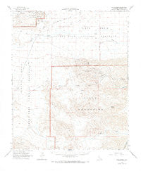
~ Pinto Basin CA topo map, 1:62500 scale, 15 X 15 Minute, Historical, 1963, updated 1968
Pinto Basin, California, USGS topographic map dated 1963.
Includes geographic coordinates (latitude and longitude). This topographic map is suitable for hiking, camping, and exploring, or framing it as a wall map.
Printed on-demand using high resolution imagery, on heavy weight and acid free paper, or alternatively on a variety of synthetic materials.
Topos available on paper, Waterproof, Poly, or Tyvek. Usually shipping rolled, unless combined with other folded maps in one order.
- Product Number: USGS-5503661
- Free digital map download (high-resolution, GeoPDF): Pinto Basin, California (file size: 6 MB)
- Map Size: please refer to the dimensions of the GeoPDF map above
- Weight (paper map): ca. 55 grams
- Map Type: POD USGS Topographic Map
- Map Series: HTMC
- Map Verison: Historical
- Cell ID: 61024
- Scan ID: 298557
- Imprint Year: 1968
- Aerial Photo Year: 1956
- Field Check Year: 1963
- Datum: NAD27
- Map Projection: Polyconic
- Map published by United States Geological Survey
- Map Language: English
- Scanner Resolution: 600 dpi
- Map Cell Name: Pinto Basin
- Grid size: 15 X 15 Minute
- Date on map: 1963
- Map Scale: 1:62500
- Geographical region: California, United States
Neighboring Maps:
All neighboring USGS topo maps are available for sale online at a variety of scales.
Spatial coverage:
Topo map Pinto Basin, California, covers the geographical area associated the following places:
- Eagle Mountains - Black Eagle Area Eagle Mountain Mine - Rusty Gold Mine - Gold Rose Well - Duplex Mine - Mystery Mine - Buzzard Spring - Smoke Tree Wash - Black Eagle Mine - Sunrise Mill (historical) - Iron Chief Mine - Conejo Well - San Bernardino Wash - Eagle Tank Spring - Mission Well - Mission Mine - Mission Sweet Mine - Meek Mine - Black Eagle Well - Golden Egg Mine - Sunset Mine - Cactus Mine - Eagle Tank - Pinto Basin - Gold Crown Mine - Placer Canyon - Central Deposit Eagle Mountain Mine - Sunrise Well - Rainbow End Mine - Storm Jade Mine
- Map Area ID: AREA3433.75-115.75-115.5
- Northwest corner Lat/Long code: USGSNW34-115.75
- Northeast corner Lat/Long code: USGSNE34-115.5
- Southwest corner Lat/Long code: USGSSW33.75-115.75
- Southeast corner Lat/Long code: USGSSE33.75-115.5
- Northern map edge Latitude: 34
- Southern map edge Latitude: 33.75
- Western map edge Longitude: -115.75
- Eastern map edge Longitude: -115.5


