
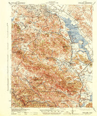
~ Petaluma CA topo map, 1:62500 scale, 15 X 15 Minute, Historical, 1942
Petaluma, California, USGS topographic map dated 1942.
Includes geographic coordinates (latitude and longitude). This topographic map is suitable for hiking, camping, and exploring, or framing it as a wall map.
Printed on-demand using high resolution imagery, on heavy weight and acid free paper, or alternatively on a variety of synthetic materials.
Topos available on paper, Waterproof, Poly, or Tyvek. Usually shipping rolled, unless combined with other folded maps in one order.
- Product Number: USGS-5503607
- Free digital map download (high-resolution, GeoPDF): Petaluma, California (file size: 12 MB)
- Map Size: please refer to the dimensions of the GeoPDF map above
- Weight (paper map): ca. 55 grams
- Map Type: POD USGS Topographic Map
- Map Series: HTMC
- Map Verison: Historical
- Cell ID: 60897
- Scan ID: 298526
- Woodland Tint: Yes
- Aerial Photo Year: 1937
- Datum: NAD27
- Map Projection: Polyconic
- Map published by United States Army Corps of Engineers
- Map published by United States Department of War
- Map Language: English
- Scanner Resolution: 600 dpi
- Map Cell Name: Petaluma
- Grid size: 15 X 15 Minute
- Date on map: 1942
- Map Scale: 1:62500
- Geographical region: California, United States
Neighboring Maps:
All neighboring USGS topo maps are available for sale online at a variety of scales.
Spatial coverage:
Topo map Petaluma, California, covers the geographical area associated the following places:
- Petaluma - Novato - Lagunitas - Dewitt - San Antonio - Terra Lindo - Gallinas - Jewell - Rafael Village - Saint Vincent - Bothin (historical) - Old Town - Irving (historical) - Nicasio - Mailliard (historical) - Haystack - Forest Knolls - Golf (historical) - Ignacio - East Petaluma - Shafter - Black Point - McNear - Marinwood - Woodacre - Bel Marin Keys - San Geronimo - Forbes (historical) - Lakeville - Las Gallinas - Sleepy Hollow - Lucas Valley - Terra Linda - Donahue (historical) - Miller (historical) - Burdell - Taylorville (historical)
- Map Area ID: AREA38.2538-122.75-122.5
- Northwest corner Lat/Long code: USGSNW38.25-122.75
- Northeast corner Lat/Long code: USGSNE38.25-122.5
- Southwest corner Lat/Long code: USGSSW38-122.75
- Southeast corner Lat/Long code: USGSSE38-122.5
- Northern map edge Latitude: 38.25
- Southern map edge Latitude: 38
- Western map edge Longitude: -122.75
- Eastern map edge Longitude: -122.5


