
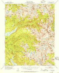
~ Mt Abbot CA topo map, 1:62500 scale, 15 X 15 Minute, Historical, 1953, updated 1955
Mt Abbot, California, USGS topographic map dated 1953.
Includes geographic coordinates (latitude and longitude). This topographic map is suitable for hiking, camping, and exploring, or framing it as a wall map.
Printed on-demand using high resolution imagery, on heavy weight and acid free paper, or alternatively on a variety of synthetic materials.
Topos available on paper, Waterproof, Poly, or Tyvek. Usually shipping rolled, unless combined with other folded maps in one order.
- Product Number: USGS-5503143
- Free digital map download (high-resolution, GeoPDF): Mt Abbot, California (file size: 11 MB)
- Map Size: please refer to the dimensions of the GeoPDF map above
- Weight (paper map): ca. 55 grams
- Map Type: POD USGS Topographic Map
- Map Series: HTMC
- Map Verison: Historical
- Cell ID: 57928
- Scan ID: 298269
- Imprint Year: 1955
- Woodland Tint: Yes
- Aerial Photo Year: 1951
- Field Check Year: 1953
- Datum: NAD27
- Map Projection: Polyconic
- Map published by United States Geological Survey
- Map Language: English
- Scanner Resolution: 600 dpi
- Map Cell Name: Mount Abbot
- Grid size: 15 X 15 Minute
- Date on map: 1953
- Map Scale: 1:62500
- Geographical region: California, United States
Neighboring Maps:
All neighboring USGS topo maps are available for sale online at a variety of scales.
Spatial coverage:
Topo map Mt Abbot, California, covers the geographical area associated the following places:
- Sharp Note Lake - Jumble Lake - Golden Creek - Marie Lake - Laurel Creek - Heart Lake - Upper Mills Creek Lake - Silver Pass Lake - Little Moccasin Lake - Lower Honeymoon Lake - Vermilion Valley 104-023 Dam - Jackson Meadow - Mount Izaak Walton - Wampum Lake - Cirque Lake - Ross Finch Lake - Mount Abbot - Florence Lake 104-009 Dam - Chickenfoot Lake - Hopkins Pass - Laurel Lake - Mount Hilgard - Sandpiper Lake - Tether Lake - Chief Lake - Chamberlain Lake - Pendant Lake - Depressed Lake - Hopkins Creek - East Fork Bear Creek - Shelf Lake - Mono Divide - Pioneer Basin Lakes - East Pinnacles Creek - Coronet Lake - Volcanic Knob - Golden Lake - Hell Hole Meadow - Graveyard Meadow - Croneys Camp - Mount Stanford - Snow Lakes - Big Bear Lake - Vermilion Cliffs - Mono Rock - Graveyard Lakes - Mount Crocker - Golden Lake - Goodale Pass - White Bear Lake - Flat Note Lake - Middle Turret Lakes - The Tombstone - Fourth Recess Lake - Frog Lake - Florence Lake Campground - Mono Creek Diversion 104-012 Dam - Mono Creek Campground - Medley Lake - Blue Jay Lakes - Mount Gabb - Selden Pass - Cirque Creek - South Fork Bear Creek - Poison Meadow - Infant Buttes - Pioneer Basin - Lower Hopkins Lake - Seven Gables Lakes - Bear Creek Spire - Toe Lake - Warrior Lake - Mace Lake - Jawbone Lake - Heart Lake - North Rock - Grinnell Lake - Olive Lake - Grassy Lake - Three Island Lake - Lagoon Lake - Morgan Pass - Italy Pass - Pemmican Lake - Lower Mills Creek Lake - MacKenzie Island - Upper Turret Lakes - Marcella Lake - Mount Julius Caesar - North Fork Mono Creek - Anne Lake - Beartrap Lake - Vermilion Valley Dam - Little McGee Lake - Lost Valley Pack Station - Stub Lake - Arrowhead Lake - Summit Lake - Red and White Mountain - Chevaux Lake
- Map Area ID: AREA37.537.25-119-118.75
- Northwest corner Lat/Long code: USGSNW37.5-119
- Northeast corner Lat/Long code: USGSNE37.5-118.75
- Southwest corner Lat/Long code: USGSSW37.25-119
- Southeast corner Lat/Long code: USGSSE37.25-118.75
- Northern map edge Latitude: 37.5
- Southern map edge Latitude: 37.25
- Western map edge Longitude: -119
- Eastern map edge Longitude: -118.75


