
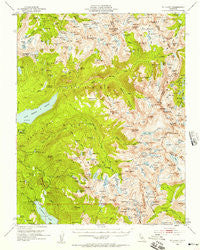
~ Mt Abbot CA topo map, 1:62500 scale, 15 X 15 Minute, Historical, 1953, updated 1957
Mt Abbot, California, USGS topographic map dated 1953.
Includes geographic coordinates (latitude and longitude). This topographic map is suitable for hiking, camping, and exploring, or framing it as a wall map.
Printed on-demand using high resolution imagery, on heavy weight and acid free paper, or alternatively on a variety of synthetic materials.
Topos available on paper, Waterproof, Poly, or Tyvek. Usually shipping rolled, unless combined with other folded maps in one order.
- Product Number: USGS-5503141
- Free digital map download (high-resolution, GeoPDF): Mt Abbot, California (file size: 11 MB)
- Map Size: please refer to the dimensions of the GeoPDF map above
- Weight (paper map): ca. 55 grams
- Map Type: POD USGS Topographic Map
- Map Series: HTMC
- Map Verison: Historical
- Cell ID: 57928
- Scan ID: 298268
- Imprint Year: 1957
- Woodland Tint: Yes
- Aerial Photo Year: 1951
- Field Check Year: 1953
- Datum: NAD27
- Map Projection: Polyconic
- Map published by United States Geological Survey
- Map Language: English
- Scanner Resolution: 600 dpi
- Map Cell Name: Mount Abbot
- Grid size: 15 X 15 Minute
- Date on map: 1953
- Map Scale: 1:62500
- Geographical region: California, United States
Neighboring Maps:
All neighboring USGS topo maps are available for sale online at a variety of scales.
Spatial coverage:
Topo map Mt Abbot, California, covers the geographical area associated the following places:
- Royce Lakes - Little McGee Lake - Middle Turret Lakes - Negit Lake - Orchid Lake - Old Squaw Lake - Big Bear Lake - Volcanic Knob - Snow Lakes - Grassy Lake - Golden Creek - Bear Dome - Mount Hilgard - Mount Gabb - Vee Lake - Heart Lake - Brave Lake - Hopkins Creek - Bear Paw Lake - Seven Gables Lakes - Ward Lake - First Recess - Graveyard Lakes - Teddy Bear Lake - Gem Lakes - North Rock - Lower Honeymoon Lake - Crocker Lake - Mount Abbot - Aweetasal Lake - Hilton Creek Lakes - South Fork Bear Creek - Mount Hopkins - Papoose Lake - Claw Lake - Neelle Lake - Vermilion Lake - Upper Mills Creek Lake - East Pinnacles Creek - Wilbur May Lake - Mount Senger - Apollo Lake - Second Recess - Florence Lake 104-009 Dam - Pocket Meadow - Lower Turret Lake - Black Bear Lake - West Fork Bear Creek - Mount Stanford - Chevaux Lake - Olive Lake - Trail Lakes - Lake Thomas A Edison - Goodale Pass - Ross Finch Lake - Pioneer Basin Lakes - Arrowhead Lake - Flat Note Lake - Florence Lake Resort - Lou Beverly Lake - Mono Creek Packstation - Mott Lake - Gemini - Poison Meadow - Mono Divide - Chamberlain Lake - Vermilion Cliffs - Bear Creek Spire - Blue Jay Lakes - Dade Lake - Devils Bathtub - Spire Lake - Hooper Diversion Dam - Silver Pass Lake - Croneys Camp - Pendant Lake - Bear Twin Lakes - Steelhead Lake - Florence Lake Campground - Graveyard Meadow - Depressed Lake - French Canyon - Mount Crocker - Grinnell Lake - Feather Lake - Sandpiper Lake - Mono Pass - Mount Huntington - Pemmican Lake - Mills Creek - Royce Peak - Stanford Lake - Jackass Meadow - Turret Peak - Little Bear Lake - Harvey Lake - Three Island Lake - Jawbone Lake - Rosemarie Meadow - Morgan Pass
- Map Area ID: AREA37.537.25-119-118.75
- Northwest corner Lat/Long code: USGSNW37.5-119
- Northeast corner Lat/Long code: USGSNE37.5-118.75
- Southwest corner Lat/Long code: USGSSW37.25-119
- Southeast corner Lat/Long code: USGSSE37.25-118.75
- Northern map edge Latitude: 37.5
- Southern map edge Latitude: 37.25
- Western map edge Longitude: -119
- Eastern map edge Longitude: -118.75


