
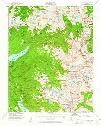
~ Mt Abbot CA topo map, 1:62500 scale, 15 X 15 Minute, Historical, 1953, updated 1960
Mt Abbot, California, USGS topographic map dated 1953.
Includes geographic coordinates (latitude and longitude). This topographic map is suitable for hiking, camping, and exploring, or framing it as a wall map.
Printed on-demand using high resolution imagery, on heavy weight and acid free paper, or alternatively on a variety of synthetic materials.
Topos available on paper, Waterproof, Poly, or Tyvek. Usually shipping rolled, unless combined with other folded maps in one order.
- Product Number: USGS-5503137
- Free digital map download (high-resolution, GeoPDF): Mt Abbot, California (file size: 10 MB)
- Map Size: please refer to the dimensions of the GeoPDF map above
- Weight (paper map): ca. 55 grams
- Map Type: POD USGS Topographic Map
- Map Series: HTMC
- Map Verison: Historical
- Cell ID: 57928
- Scan ID: 298267
- Imprint Year: 1960
- Woodland Tint: Yes
- Aerial Photo Year: 1951
- Field Check Year: 1953
- Datum: NAD27
- Map Projection: Polyconic
- Map published by United States Geological Survey
- Map Language: English
- Scanner Resolution: 600 dpi
- Map Cell Name: Mount Abbot
- Grid size: 15 X 15 Minute
- Date on map: 1953
- Map Scale: 1:62500
- Geographical region: California, United States
Neighboring Maps:
All neighboring USGS topo maps are available for sale online at a variety of scales.
Spatial coverage:
Topo map Mt Abbot, California, covers the geographical area associated the following places:
- Graveyard Meadow - Hortense Lake - Chief Lake - Bear Diversion Dam - Mist Lake - Hooper Diversion Dam - Pioneer Basin - Vermilion Valley 104-023 Dam - Ursa Lake - Silver Pass Lake - Chickenfoot Lake - Stub Lake - Mount Senger - Infant Buttes - Summit Lake - Den Lake - Mount Mills - Mount Hilgard - Sharp Note Lake - Anne Lake - Brave Lake - Silver Pass - Upper Graveyard Meadow - Snow Lakes - Frog Lake - Fish Camp - Jackass Meadow - Brown Bear Lake - Morgan Pass - Bear Dome - Marshall Lake - Golden Lake - Mace Lake - Devils Bathtub - Big Bear Lake - Mills Creek - Lost Valley Pack Station - Crater Creek - Grinnell Lake - Royce Peak - Royce Lakes - First Recess - Vermilion Valley Dam - Graveyard Peak - Third Recess Lake - French Canyon - Teddy Bear Lake - Bear Creek Diversion 104-000 Dam - Gem Lakes - Little Lakes - Peter Pande Lake - Coronet Lake - West Fork Bear Creek - Florence Lake - Mono Rock - Mono Creek Diversion 104-012 Dam - Papoose Lake - Rosebud Lake - Lake Thomas A Edison - Granite Park - Pick and Shovel Mine - Lower Turret Lake - Vermilion Cliffs - Upper Turret Lakes - Golden Creek - Little McGee Lake - Medley Lake - Pocket Meadow - Hell Hole Meadow - Upper Vermillion Campground - Cirque Lake - Ross Finch Lake - Kip Camp - Hooper Lake - Hutchinson Meadow - Little Grinnell Lake - The Tombstone - Bear Creek Spire - Big Moccasin Lake - Fourth Recess Lake - Mills Lake - Foolish Lake - Mount Starr - Toe Lake - Mount Izaak Walton - Mono Pass - Sallie Keyes Lakes - Red and White Lake - Goodale Pass - Spire Lake - High Sierra Packstation - Mount Abbot - Crocker Lake - Olive Lake - Lake of the Lone Indian - Hopkins Pass - Chalfant Lakes - Mount Hooper - Lower Mills Creek Lake - Dutch Lake
- Map Area ID: AREA37.537.25-119-118.75
- Northwest corner Lat/Long code: USGSNW37.5-119
- Northeast corner Lat/Long code: USGSNE37.5-118.75
- Southwest corner Lat/Long code: USGSSW37.25-119
- Southeast corner Lat/Long code: USGSSE37.25-118.75
- Northern map edge Latitude: 37.5
- Southern map edge Latitude: 37.25
- Western map edge Longitude: -119
- Eastern map edge Longitude: -118.75


