
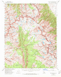
~ Mount Whitney CA topo map, 1:62500 scale, 15 X 15 Minute, Historical, 1967, updated 1972
Mount Whitney, California, USGS topographic map dated 1967.
Includes geographic coordinates (latitude and longitude). This topographic map is suitable for hiking, camping, and exploring, or framing it as a wall map.
Printed on-demand using high resolution imagery, on heavy weight and acid free paper, or alternatively on a variety of synthetic materials.
Topos available on paper, Waterproof, Poly, or Tyvek. Usually shipping rolled, unless combined with other folded maps in one order.
- Product Number: USGS-5503123
- Free digital map download (high-resolution, GeoPDF): Mount Whitney, California (file size: 10 MB)
- Map Size: please refer to the dimensions of the GeoPDF map above
- Weight (paper map): ca. 55 grams
- Map Type: POD USGS Topographic Map
- Map Series: HTMC
- Map Verison: Historical
- Cell ID: 58145
- Scan ID: 298260
- Imprint Year: 1972
- Woodland Tint: Yes
- Aerial Photo Year: 1955
- Edit Year: 1967
- Field Check Year: 1956
- Datum: NAD27
- Map Projection: Polyconic
- Map published by United States Geological Survey
- Map Language: English
- Scanner Resolution: 600 dpi
- Map Cell Name: Mount Whitney
- Grid size: 15 X 15 Minute
- Date on map: 1967
- Map Scale: 1:62500
- Geographical region: California, United States
Neighboring Maps:
All neighboring USGS topo maps are available for sale online at a variety of scales.
Spatial coverage:
Topo map Mount Whitney, California, covers the geographical area associated the following places:
- Longley Pass - Mount Barnard - Mount Guyot - Wotans Throne - Keeler Needle - Tawny Point - Mirror Lake - Frog Pond - Shepherd Pass - Center Peak - Mount Hitchcock - Guitar Lake - Mount Hale - Milestone Bowl - Diamond Mesa - Mount Marsh - Mount Stanford - Junction Pass - Guyot Flat - The Pothole - The Major General - Mount Jordan - Forester Pass - West Spur - Lake Helen of Troy - Junction Meadow - Williamson Bowl - Crooks Peak - Centennial Peak - Milestone Creek - Tunnabora Peak - Ouzel Creek - Timberline Lake - Anvil Camp - Crabtree Meadow - Williamson Creek - Mount McAdie - Lower Boy Scout Lake - Bighorn Park - Erin Lake - Rockslide Lake - North Guard Lake - Clyde Meadow - Mount Williamson - Mount Tyndall - Mount Le Conte - Wright Lakes - Picket Guard Peak - Whitney Pass - Sheep Pass (historical) - Deerhorn Mountain - Whitney Creek - University Peak - Sierra Nevada - Mount Genevra - Tyndall Creek - Gregorys Monument - Wright Creek - Mount Brewer - Kern-Kaweah River - Tyndall Creek Ranger Station - Mount Farquhar - Mount Young - Gallats Lake - Mount Pickering - Shepherd Pass Trailhead - Kaweah Basin - Wales Lake - Mount Keith - Mahogany Flat - Mount Newcomb - Kern Ridge - Mount Bradley - Primrose Lake - Sky Blue Lake - Arc Pass - Vacation Pass - Caltech Peak - Wallace Lake - Center Basin Crags - Meysan Lake - Pinnacle Ridge - Consultation Lake - Iridescent Lake - North Guard - Vidette Lakes - Lake South America - Mount Mallory - Lucys Foot Pass - East Lake - Mount Ericsson - Hitchcock Lakes - Joe Devel Peak - Thor Peak - Trojan Peak - Mount Kaweah - Mount Whitney Trail - Mount Irvine - Mount Whitney - Discovery Pinnacle
- Map Area ID: AREA36.7536.5-118.5-118.25
- Northwest corner Lat/Long code: USGSNW36.75-118.5
- Northeast corner Lat/Long code: USGSNE36.75-118.25
- Southwest corner Lat/Long code: USGSSW36.5-118.5
- Southeast corner Lat/Long code: USGSSE36.5-118.25
- Northern map edge Latitude: 36.75
- Southern map edge Latitude: 36.5
- Western map edge Longitude: -118.5
- Eastern map edge Longitude: -118.25


