
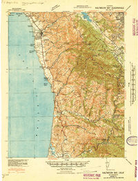
~ Halfmoon Bay CA topo map, 1:62500 scale, 15 X 15 Minute, Historical, 1940
Halfmoon Bay, California, USGS topographic map dated 1940.
Includes geographic coordinates (latitude and longitude). This topographic map is suitable for hiking, camping, and exploring, or framing it as a wall map.
Printed on-demand using high resolution imagery, on heavy weight and acid free paper, or alternatively on a variety of synthetic materials.
Topos available on paper, Waterproof, Poly, or Tyvek. Usually shipping rolled, unless combined with other folded maps in one order.
- Product Number: USGS-5502027
- Free digital map download (high-resolution, GeoPDF): Halfmoon Bay, California (file size: 10 MB)
- Map Size: please refer to the dimensions of the GeoPDF map above
- Weight (paper map): ca. 55 grams
- Map Type: POD USGS Topographic Map
- Map Series: HTMC
- Map Verison: Historical
- Cell ID: 54993
- Scan ID: 297628
- Woodland Tint: Yes
- Aerial Photo Year: 1939
- Survey Year: 1940
- Datum: NAD27
- Map Projection: Polyconic
- Advance: Yes
- Map published by United States Army Corps of Engineers
- Map published by United States Department of War
- Map Language: English
- Scanner Resolution: 600 dpi
- Map Cell Name: Half Moon Bay
- Grid size: 15 X 15 Minute
- Date on map: 1940
- Map Scale: 1:62500
- Geographical region: California, United States
Neighboring Maps:
All neighboring USGS topo maps are available for sale online at a variety of scales.
Spatial coverage:
Topo map Halfmoon Bay, California, covers the geographical area associated the following places:
- Emerald Lake Hills - Loma Mar - Purisima (historical) - Farm Hills - Bellvale - Woodside Glens - Palomar Park - Redwood Park - Adobe Corner - Miramar - Emerald Lake - La Honda - Lobitos - Woodside - Half Moon Bay - Redwood Terrace - Canada Home Mobile Home Park - Grabtown - Martins Beach - Pescadero - Sky Londa - Dearborn Park - San Gregorio - Accent Homes Mobile Home Park
- Map Area ID: AREA37.537.25-122.5-122.25
- Northwest corner Lat/Long code: USGSNW37.5-122.5
- Northeast corner Lat/Long code: USGSNE37.5-122.25
- Southwest corner Lat/Long code: USGSSW37.25-122.5
- Southeast corner Lat/Long code: USGSSE37.25-122.25
- Northern map edge Latitude: 37.5
- Southern map edge Latitude: 37.25
- Western map edge Longitude: -122.5
- Eastern map edge Longitude: -122.25


