
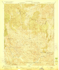
~ Gilroy Hot Springs CA topo map, 1:62500 scale, 15 X 15 Minute, Historical, 1921
Gilroy Hot Springs, California, USGS topographic map dated 1921.
Includes geographic coordinates (latitude and longitude). This topographic map is suitable for hiking, camping, and exploring, or framing it as a wall map.
Printed on-demand using high resolution imagery, on heavy weight and acid free paper, or alternatively on a variety of synthetic materials.
Topos available on paper, Waterproof, Poly, or Tyvek. Usually shipping rolled, unless combined with other folded maps in one order.
- Product Number: USGS-5501905
- Free digital map download (high-resolution, GeoPDF): Gilroy Hot Springs, California (file size: 11 MB)
- Map Size: please refer to the dimensions of the GeoPDF map above
- Weight (paper map): ca. 55 grams
- Map Type: POD USGS Topographic Map
- Map Series: HTMC
- Map Verison: Historical
- Cell ID: 54590
- Scan ID: 297556
- Woodland Tint: Yes
- Survey Year: 1918
- Datum: NAD
- Map Projection: Polyconic
- Map published by United States Geological Survey
- Map published by United States Army Corps of Engineers
- Map published by United States Department of War
- Map Language: English
- Scanner Resolution: 600 dpi
- Map Cell Name: Gilroy Hot Springs
- Grid size: 15 X 15 Minute
- Date on map: 1921
- Map Scale: 1:62500
- Geographical region: California, United States
Neighboring Maps:
All neighboring USGS topo maps are available for sale online at a variety of scales.
Spatial coverage:
Topo map Gilroy Hot Springs, California, covers the geographical area associated the following places:
- Shaeirn Ranch - Kelly Cabin Canyon - Middle Fork Coyote Creek - Elephant Head Ridge - Willson Peak - Gulnac Peak - Pacheco Peak - Hog Canyon - East Fork Pacheco Creek - Shaeirn Lake - Gilroy Hot Springs - Mustang Peak - Pacheco Lake - Kaufman Ridge - Cow Canyon - Chimney Canyon - North Fork Dam - Coit Dam - O'Connor Ranch - Bear Springs - Willow Ridge - Pigeon Point - Hurricane Canyon - Black Hill - Bell Station - Board Springs - Cedar Creek - Harper Canyon - Rock House Ridge - Bills Hill - Rooster Comb - Murry 1620-003 Dam - Kelly Cabin Canyon 1620-002 Dam - Hunting Hollow - Bulhead Reservoir - Cañada De Los Osos - Center Flats - Lake Mountain - Elephant Head Creek - Red Creek - Palassou Ridge - North Fork Pacheco Creek - Chimney Rock - Little Rough Gulch - Willson Ranch - Oak Springs Reservoir - Bullhead Canyon - Mustang Flat - Mustang Canyon - Dowdy Ranch - The Narrows - Chimney Gulch - Dexter Canyon - Phegley Ridge - East Fork Coyote Creek - Hamner Hill - Pine Spring Canyon - Bear Mountain - Paradise Flat - Water Gulch - Cañada De La Dormida - Turkey Flat - Buckeye Canyon - Pine Springs Hill - Braen Canyon - Lovers Leap - Elephant Head - Coon Hunters Gulch - Soda Springs Canyon - Vasquez Peak - South Fork Pacheco Creek - Department of Forestry and Fire Protection Station 21 Coyote - Hartman Creek - Gill Ranch - Rough Gulch - Department of Forestry and Fire Protection Station 31 Pacheco - Kickham Peak - Big Canyon - Coit Lake - Rock Springs Peak - Coon Creek - Mississippi Creek - Mustang Ridge - Hoover Lake - Burra Burra Peak - Pacheco Ranger Station - Bear Creek - Hagerman Canyon
- Map Area ID: AREA37.2537-121.5-121.25
- Northwest corner Lat/Long code: USGSNW37.25-121.5
- Northeast corner Lat/Long code: USGSNE37.25-121.25
- Southwest corner Lat/Long code: USGSSW37-121.5
- Southeast corner Lat/Long code: USGSSE37-121.25
- Northern map edge Latitude: 37.25
- Southern map edge Latitude: 37
- Western map edge Longitude: -121.5
- Eastern map edge Longitude: -121.25


