
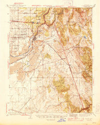
~ Folsom CA topo map, 1:62500 scale, 15 X 15 Minute, Historical, 1944
Folsom, California, USGS topographic map dated 1944.
Includes geographic coordinates (latitude and longitude). This topographic map is suitable for hiking, camping, and exploring, or framing it as a wall map.
Printed on-demand using high resolution imagery, on heavy weight and acid free paper, or alternatively on a variety of synthetic materials.
Topos available on paper, Waterproof, Poly, or Tyvek. Usually shipping rolled, unless combined with other folded maps in one order.
- Product Number: USGS-5501765
- Free digital map download (high-resolution, GeoPDF): Folsom, California (file size: 9 MB)
- Map Size: please refer to the dimensions of the GeoPDF map above
- Weight (paper map): ca. 55 grams
- Map Type: POD USGS Topographic Map
- Map Series: HTMC
- Map Verison: Historical
- Cell ID: 54221
- Scan ID: 297477
- Woodland Tint: Yes
- Survey Year: 1941
- Datum: NAD27
- Map Projection: Polyconic
- Map published by United States Geological Survey
- Map published by United States Department of War
- Map Language: English
- Scanner Resolution: 600 dpi
- Map Cell Name: Folsom
- Grid size: 15 X 15 Minute
- Date on map: 1944
- Map Scale: 1:62500
- Geographical region: California, United States
Neighboring Maps:
All neighboring USGS topo maps are available for sale online at a variety of scales.
Spatial coverage:
Topo map Folsom, California, covers the geographical area associated the following places:
- Easton Place - Ridgeview Village - Highland Village - Green Springs Ranch - Equestrian Village - Briarwood Canyon - Hickok Ranch - Oak Creek Hills - Bar J Ranch - Crescent Ridge Village - Green Springs Valley - Lake Hills Estates - Franciscan Village - Glenborough - Folsom Junction - Alder Creek - Marina Village - Walltown - Gold River - Park Village - Hidden Valley - Saint Andrews Village - Manzanita Acres - Oak Tree Village - Governors Village - Marble Mountain - Prairie City - Waterford Village - Nimbus - Cambridge Oaks - Arroyo Vista - Natoma - Springfield Meadows - Lakeridge Oaks - Winterhaven Village - Malby Crossing - Stonegate Village - Clarksville - Oak Ridge Village - Sunset Mobile Home Park - Summit Village - Rancho Murieta - Green Valley Acres - Folsom - El Dorado Hills - Orangevale - Crown Village - La Cresta Village - White Rock
- Map Area ID: AREA38.7538.5-121.25-121
- Northwest corner Lat/Long code: USGSNW38.75-121.25
- Northeast corner Lat/Long code: USGSNE38.75-121
- Southwest corner Lat/Long code: USGSSW38.5-121.25
- Southeast corner Lat/Long code: USGSSE38.5-121
- Northern map edge Latitude: 38.75
- Southern map edge Latitude: 38.5
- Western map edge Longitude: -121.25
- Eastern map edge Longitude: -121


