
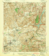
~ El Cajon CA topo map, 1:62500 scale, 15 X 15 Minute, Historical, 1942
El Cajon, California, USGS topographic map dated 1942.
Includes geographic coordinates (latitude and longitude). This topographic map is suitable for hiking, camping, and exploring, or framing it as a wall map.
Printed on-demand using high resolution imagery, on heavy weight and acid free paper, or alternatively on a variety of synthetic materials.
Topos available on paper, Waterproof, Poly, or Tyvek. Usually shipping rolled, unless combined with other folded maps in one order.
- Product Number: USGS-5501599
- Free digital map download (high-resolution, GeoPDF): El Cajon, California (file size: 11 MB)
- Map Size: please refer to the dimensions of the GeoPDF map above
- Weight (paper map): ca. 55 grams
- Map Type: POD USGS Topographic Map
- Map Series: HTMC
- Map Verison: Historical
- Cell ID: 53765
- Scan ID: 297390
- Woodland Tint: Yes
- Survey Year: 1939
- Datum: NAD27
- Map Projection: Polyconic
- Preliminary map: Yes
- Map published by United States Geological Survey
- Map Language: English
- Scanner Resolution: 600 dpi
- Map Cell Name: El Cajon
- Grid size: 15 X 15 Minute
- Date on map: 1942
- Map Scale: 1:62500
- Geographical region: California, United States
Neighboring Maps:
All neighboring USGS topo maps are available for sale online at a variety of scales.
Spatial coverage:
Topo map El Cajon, California, covers the geographical area associated the following places:
- Lakeview - Cajon Heights - Barona - Harbison Canyon - Hillsdale - Mount Helix - Irvings Crest - Crest - Suncrest - Blossom Valley - Moreno - Granite Hills - Bostonia - Boulder Oaks - Santee - Dehesa - El Cajon - Calavo Gardens - Camerons Mobile Home Park - Hawaiian Village Mobile Home Park - Flinn Springs - New Frontier Mobile Home Park - Alpine - El Capitan (historical) - Riverview Farms - Grossmont - Shady Dell - La Cresta - Alpine Heights - Johnstown - Mussey Grove (historical) - Alta (historical) - Fernbrook - Glen Oaks - Town and Country Mobile Home Park - Riverview - Eucalyptus Hills - Rock Haven (historical) - Four Corners - Foster - Glenview - Winter Gardens - Carlton Hills - Lakeside - Lakeside Farms - Mission del Magnolia Mobile Home Park
- Map Area ID: AREA3332.75-117-116.75
- Northwest corner Lat/Long code: USGSNW33-117
- Northeast corner Lat/Long code: USGSNE33-116.75
- Southwest corner Lat/Long code: USGSSW32.75-117
- Southeast corner Lat/Long code: USGSSE32.75-116.75
- Northern map edge Latitude: 33
- Southern map edge Latitude: 32.75
- Western map edge Longitude: -117
- Eastern map edge Longitude: -116.75


