
~ Downey CA topo map, 1:62500 scale, 15 X 15 Minute, Historical, 1943, updated 1963
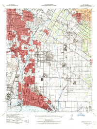
Downey, California, USGS topographic map dated 1943.
Includes geographic coordinates (latitude and longitude). This topographic map is suitable for hiking, camping, and exploring, or framing it as a wall map.
Printed on-demand using high resolution imagery, on heavy weight and acid free paper, or alternatively on a variety of synthetic materials.
Topos available on paper, Waterproof, Poly, or Tyvek. Usually shipping rolled, unless combined with other folded maps in one order.
- Product Number: USGS-5501503
- Free digital map download (high-resolution, GeoPDF): Downey, California (file size: 9 MB)
- Map Size: please refer to the dimensions of the GeoPDF map above
- Weight (paper map): ca. 55 grams
- Map Type: POD USGS Topographic Map
- Map Series: HTMC
- Map Verison: Historical
- Cell ID: 53532
- Scan ID: 297336
- Imprint Year: 1963
- Woodland Tint: Yes
- Aerial Photo Year: 1939
- Survey Year: 1904
- Datum: NAD27
- Map Projection: Polyconic
- Map published by United States Army Corps of Engineers
- Map published by United States Department of War
- Map Language: English
- Scanner Resolution: 600 dpi
- Map Cell Name: Downey
- Grid size: 15 X 15 Minute
- Date on map: 1943
- Map Scale: 1:62500
- Geographical region: California, United States
Neighboring Maps:
All neighboring USGS topo maps are available for sale online at a variety of scales.
Spatial coverage:
Topo map Downey, California, covers the geographical area associated the following places:
- Lakewood - Friendly Hills - Moody - Colima - North Long Beach - Gaspur (historical) - Cambodia Town - Hansen - La Mirada - Whittier - East Rancho Dominguez - Graham - Carmenita - Clearwater - Watts - Halcon - Valla - Lynwood Gardens - Rio Hondo - Hawaiian Gardens - Barber City - Lincoln Center Mobile Home Park - Huntington Park - El Rancho Mobile Home Park - Pueblo Del Rio Public Housing - Willowville - McCampbell - West Whittier - Bluff Park - Paramount - Rossmoor - East Whittier - Bangle - Dominguez - Imperial Courts - Los Robles Mobile Home Park - South Gate - Los Nietos - Fulton Wells - Norwalk - Los Nietos Junction - Compton - Watson - Naples - Douglas Junction - Santa Fe Springs - Bell Gardens - Florence - Vista del Mar - Bandini - Gage - Simons - Artesia - Walnut Park - Cota - Rendalia - South Whittier - Laguna - Long Beach - Workman - Jordan Downs - Lincoln Village - Firestone Park - Cerritos - Dominguez Junction - Rose Park - Leisure World - Del Amo - Bixby Knolls - Willow Brook - Los Alisos Mobile Home Estates - Walker - Elftman - Cypress - Royal Oak Mobile Home Park - Thenard - Morton - Hacienda Village - Los Alamitos - Dolley - Vinvale - Pico Rivera - Hollydale - Shirley - Los Altos - Belmont Shore - Nadeau - Bellflower - Bingham - Studebaker - Downey - Dolores - Downey Road - Signal Hill - Nickerson Gardens - Cudahy - Belmont Heights - Bell - California Heights - Maywood
- Map Area ID: AREA3433.75-118.25-118
- Northwest corner Lat/Long code: USGSNW34-118.25
- Northeast corner Lat/Long code: USGSNE34-118
- Southwest corner Lat/Long code: USGSSW33.75-118.25
- Southeast corner Lat/Long code: USGSSE33.75-118
- Northern map edge Latitude: 34
- Southern map edge Latitude: 33.75
- Western map edge Longitude: -118.25
- Eastern map edge Longitude: -118


