
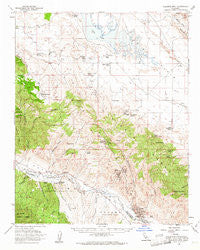
~ Caliente Mountain CA topo map, 1:62500 scale, 15 X 15 Minute, Historical, 1959, updated 1961
Caliente Mountain, California, USGS topographic map dated 1959.
Includes geographic coordinates (latitude and longitude). This topographic map is suitable for hiking, camping, and exploring, or framing it as a wall map.
Printed on-demand using high resolution imagery, on heavy weight and acid free paper, or alternatively on a variety of synthetic materials.
Topos available on paper, Waterproof, Poly, or Tyvek. Usually shipping rolled, unless combined with other folded maps in one order.
- Product Number: USGS-5500853
- Free digital map download (high-resolution, GeoPDF): Caliente Mountain, California (file size: 9 MB)
- Map Size: please refer to the dimensions of the GeoPDF map above
- Weight (paper map): ca. 55 grams
- Map Type: POD USGS Topographic Map
- Map Series: HTMC
- Map Verison: Historical
- Cell ID: 52024
- Scan ID: 296970
- Imprint Year: 1961
- Woodland Tint: Yes
- Aerial Photo Year: 1953
- Datum: NAD27
- Map Projection: Polyconic
- Map published by United States Geological Survey
- Map Language: English
- Scanner Resolution: 600 dpi
- Map Cell Name: Caliente Mountain
- Grid size: 15 X 15 Minute
- Date on map: 1959
- Map Scale: 1:62500
- Geographical region: California, United States
Neighboring Maps:
All neighboring USGS topo maps are available for sale online at a variety of scales.
Spatial coverage:
Topo map Caliente Mountain, California, covers the geographical area associated the following places:
- Chimineas Ranch - Taylor Canyon Oil Field - Sulphur Spring - Morales Canyon Oil Field - Carrizo Plain - American Ranch - Schoolhouse Canyon - Caliente Range - Black Sulphur Spring - Goodwin Ranch - Kelly Canyon - Green Valley Ranch Number Two - Spoor Canyon - Morales Canyon - Whiterock Bluff - Miranda Canyon - Carrizo Canyon - Mustang Canyon - Spanish Ranch - Saucito Ranch - Russel Ranch Oil Field - Washburn Ranch - Kelsey Canyon - R C Farm - Sheep Camp - Cottonwood Spring - Chalk Mountain - Saltos Canyon - Taylor Spring - Cottonwood Canyon - Pearson Spring - Goat Spring - Cuyama - Turkey Camp Well - Selby Ranch - Soda Lake - Selby Ranch Cow Camp - Post Canyon - Powell Canyon - Painted Rock - Painted Rock Ranch - Taylor Canyon - Government Eighteen Oil Field - Deadman Flat - Big Spring - Turkey Camp - Red Rock Canyon - Caliente Mountain
- Map Area ID: AREA35.2535-120-119.75
- Northwest corner Lat/Long code: USGSNW35.25-120
- Northeast corner Lat/Long code: USGSNE35.25-119.75
- Southwest corner Lat/Long code: USGSSW35-120
- Southeast corner Lat/Long code: USGSSE35-119.75
- Northern map edge Latitude: 35.25
- Southern map edge Latitude: 35
- Western map edge Longitude: -120
- Eastern map edge Longitude: -119.75


