
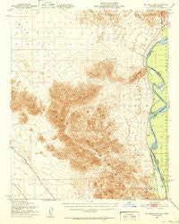
~ Big Maria Mts CA topo map, 1:62500 scale, 15 X 15 Minute, Historical, 1951, updated 1952
Big Maria Mts, California, USGS topographic map dated 1951.
Includes geographic coordinates (latitude and longitude). This topographic map is suitable for hiking, camping, and exploring, or framing it as a wall map.
Printed on-demand using high resolution imagery, on heavy weight and acid free paper, or alternatively on a variety of synthetic materials.
Topos available on paper, Waterproof, Poly, or Tyvek. Usually shipping rolled, unless combined with other folded maps in one order.
- Product Number: USGS-5500531
- Free digital map download (high-resolution, GeoPDF): Big Maria Mts, California (file size: 8 MB)
- Map Size: please refer to the dimensions of the GeoPDF map above
- Weight (paper map): ca. 55 grams
- Map Type: POD USGS Topographic Map
- Map Series: HTMC
- Map Verison: Historical
- Cell ID: 51367
- Scan ID: 296800
- Imprint Year: 1952
- Woodland Tint: Yes
- Aerial Photo Year: 1940
- Datum: NAD27
- Map Projection: Polyconic
- Map published by United States Geological Survey
- Map published by United States Army Corps of Engineers
- Map published by United States Army
- Map Language: English
- Scanner Resolution: 600 dpi
- Map Cell Name: Big Maria Mountains
- Grid size: 15 X 15 Minute
- Date on map: 1951
- Map Scale: 1:62500
- Geographical region: California, United States
Neighboring Maps:
All neighboring USGS topo maps are available for sale online at a variety of scales.
Spatial coverage:
Topo map Big Maria Mts, California, covers the geographical area associated the following places:
- River Bend Lodge - Slaughter Tree Wash - Water Wheel Camp - Thompsons Camp - Quien Sabe Point - Halfway Bend - Hills Ranch - Rice Valley Wilderness - Giant Indian Intaglios - Big Maria Mountains Wilderness - Barrie Island - Black Hill - Rice Valley - Hall Island - Blythe Boat Club - Big Maria Mountains - Riverside County Fire Department Station 46 Riverbend - Aha-quin Airport (historical) - Haakers Camp - Big Wash - Black Point - Horse Island
- Map Area ID: AREA3433.75-114.75-114.5
- Northwest corner Lat/Long code: USGSNW34-114.75
- Northeast corner Lat/Long code: USGSNE34-114.5
- Southwest corner Lat/Long code: USGSSW33.75-114.75
- Southeast corner Lat/Long code: USGSSE33.75-114.5
- Northern map edge Latitude: 34
- Southern map edge Latitude: 33.75
- Western map edge Longitude: -114.75
- Eastern map edge Longitude: -114.5


