
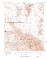
~ Avawatz Pass CA topo map, 1:62500 scale, 15 X 15 Minute, Historical, 1948, updated 1969
Avawatz Pass, California, USGS topographic map dated 1948.
Includes geographic coordinates (latitude and longitude). This topographic map is suitable for hiking, camping, and exploring, or framing it as a wall map.
Printed on-demand using high resolution imagery, on heavy weight and acid free paper, or alternatively on a variety of synthetic materials.
Topos available on paper, Waterproof, Poly, or Tyvek. Usually shipping rolled, unless combined with other folded maps in one order.
- Product Number: USGS-5500447
- Free digital map download (high-resolution, GeoPDF): Avawatz Pass, California (file size: 10 MB)
- Map Size: please refer to the dimensions of the GeoPDF map above
- Weight (paper map): ca. 55 grams
- Map Type: POD USGS Topographic Map
- Map Series: HTMC
- Map Verison: Historical
- Cell ID: 50813
- Scan ID: 296747
- Imprint Year: 1969
- Aerial Photo Year: 1948
- Field Check Year: 1948
- Datum: NAD27
- Map Projection: Polyconic
- Map published by United States Geological Survey
- Map published by United States Army Corps of Engineers
- Map Language: English
- Scanner Resolution: 600 dpi
- Map Cell Name: Avawatz Pass
- Grid size: 15 X 15 Minute
- Date on map: 1948
- Map Scale: 1:62500
- Geographical region: California, United States
Neighboring Maps:
All neighboring USGS topo maps are available for sale online at a variety of scales.
Spatial coverage:
Topo map Avawatz Pass, California, covers the geographical area associated the following places:
- Salt Creek - Arrastre Spring - Saratoga Spring - Avawatz Mountains - Buckwheat Wash - Little Dumont Dunes - Anvil Canyon - Amargosa Spring - Denning Spring - Salt Spring Hills - White Cap Mine - Cottonwood Spring - Superior Mine - Old Ibex Pass - Saratoga Mine - Sheep Creek Mine - Old Mormon Spring - Ibex Dunes - Avawatz Pass - Saddle Peak Hills - Silurian Valley - Sheep Creek Spring - Cave Spring - Pogo Mine - Salt Creek Hills ACEC - Ibex Wash
- Map Area ID: AREA35.7535.5-116.5-116.25
- Northwest corner Lat/Long code: USGSNW35.75-116.5
- Northeast corner Lat/Long code: USGSNE35.75-116.25
- Southwest corner Lat/Long code: USGSSW35.5-116.5
- Southeast corner Lat/Long code: USGSSE35.5-116.25
- Northern map edge Latitude: 35.75
- Southern map edge Latitude: 35.5
- Western map edge Longitude: -116.5
- Eastern map edge Longitude: -116.25


