
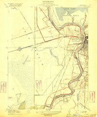
~ Lovdal CA topo map, 1:31680 scale, 7.5 X 7.5 Minute, Historical, 1916
Lovdal, California, USGS topographic map dated 1916.
Includes geographic coordinates (latitude and longitude). This topographic map is suitable for hiking, camping, and exploring, or framing it as a wall map.
Printed on-demand using high resolution imagery, on heavy weight and acid free paper, or alternatively on a variety of synthetic materials.
Topos available on paper, Waterproof, Poly, or Tyvek. Usually shipping rolled, unless combined with other folded maps in one order.
- Product Number: USGS-5499637
- Free digital map download (high-resolution, GeoPDF): Lovdal, California (file size: 6 MB)
- Map Size: please refer to the dimensions of the GeoPDF map above
- Weight (paper map): ca. 55 grams
- Map Type: POD USGS Topographic Map
- Map Series: HTMC
- Map Verison: Historical
- Cell ID: 39130
- Scan ID: 296281
- Woodland Tint: Yes
- Survey Year: 1905
- Datum: Unstated
- Map Projection: Unstated
- Map published by United States Geological Survey
- Map Language: English
- Scanner Resolution: 600 dpi
- Map Cell Name: Sacramento West
- Grid size: 7.5 X 7.5 Minute
- Date on map: 1916
- Map Scale: 1:31680
- Geographical region: California, United States
Neighboring Maps:
All neighboring USGS topo maps are available for sale online at a variety of scales.
Spatial coverage:
Topo map Lovdal, California, covers the geographical area associated the following places:
- El Rancho Mobile Park - Lovdal - Plumtree (historical) - Trails End Mobile Home Park - Walnut Trailer Villa - West Sacramento - Mikon - Riverside - Riverside Mobile Home Park - Kobe (historical) - Leeman (historical) - Capitol City Recreational Vehicle and Mobile Home Park - Broderick - Silvas Grove (historical) - Capri Mobile Home Park - Peethill - Bryte Mobile Home Park - Skylark Mobile Home Park - West Sacramento Trailer Park - Westwind Estates - Bryte - Casa Mobile Home Park - Garden Acres Mobile Home Park - Riverview
- Map Area ID: AREA38.62538.5-121.625-121.5
- Northwest corner Lat/Long code: USGSNW38.625-121.625
- Northeast corner Lat/Long code: USGSNE38.625-121.5
- Southwest corner Lat/Long code: USGSSW38.5-121.625
- Southeast corner Lat/Long code: USGSSE38.5-121.5
- Northern map edge Latitude: 38.625
- Southern map edge Latitude: 38.5
- Western map edge Longitude: -121.625
- Eastern map edge Longitude: -121.5


