
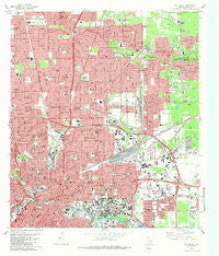
~ Settegast TX topo map, 1:24000 scale, 7.5 X 7.5 Minute, Historical, 1982, updated 1983
Settegast, Texas, USGS topographic map dated 1982.
Includes geographic coordinates (latitude and longitude). This topographic map is suitable for hiking, camping, and exploring, or framing it as a wall map.
Printed on-demand using high resolution imagery, on heavy weight and acid free paper, or alternatively on a variety of synthetic materials.
Topos available on paper, Waterproof, Poly, or Tyvek. Usually shipping rolled, unless combined with other folded maps in one order.
- Product Number: USGS-5494055
- Free digital map download (high-resolution, GeoPDF): Settegast, Texas (file size: 19 MB)
- Map Size: please refer to the dimensions of the GeoPDF map above
- Weight (paper map): ca. 55 grams
- Map Type: POD USGS Topographic Map
- Map Series: HTMC
- Map Verison: Historical
- Cell ID: 40615
- Scan ID: 121318
- Imprint Year: 1983
- Woodland Tint: Yes
- Visual Version Number: 0
- Aerial Photo Year: 1976
- Edit Year: 1982
- Field Check Year: 1976
- Datum: NAD27
- Map Projection: Lambert Conformal Conic
- Map published by United States Geological Survey
- Map Language: English
- Scanner Resolution: 600 dpi
- Map Cell Name: Settegast
- Grid size: 7.5 X 7.5 Minute
- Date on map: 1982
- Map Scale: 1:24000
- Geographical region: Texas, United States
Neighboring Maps:
All neighboring USGS topo maps are available for sale online at a variety of scales.
Spatial coverage:
Topo map Settegast, Texas, covers the geographical area associated the following places:
- East Houston - Calgary Woods - Kentshire Place - Sherwood Place - Settegast - North Shadydale - Woodglen - Pembroke Place - Scenic Woods Plaza - Glen Park - Westfield Estates - Rosedale Gardens - Farrington Place - Fontaine Place - Barclay Place - El Dorado - Knollwood Estates - Houston - Colonial Gardens - Epson Downs - Scenic Woods - Pelham Place - Melrose Park - Shady Timbers - Pinewood Village - Chatwood Place - Woodsdale - Forest Green - Hawthorne Place - Plymouth Place
- Map Area ID: AREA29.87529.75-95.375-95.25
- Northwest corner Lat/Long code: USGSNW29.875-95.375
- Northeast corner Lat/Long code: USGSNE29.875-95.25
- Southwest corner Lat/Long code: USGSSW29.75-95.375
- Southeast corner Lat/Long code: USGSSE29.75-95.25
- Northern map edge Latitude: 29.875
- Southern map edge Latitude: 29.75
- Western map edge Longitude: -95.375
- Eastern map edge Longitude: -95.25


