
~ Mount Livermore TX topo map, 1:24000 scale, 7.5 X 7.5 Minute, Historical, 1978, updated 1978
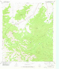
Mount Livermore, Texas, USGS topographic map dated 1978.
Includes geographic coordinates (latitude and longitude). This topographic map is suitable for hiking, camping, and exploring, or framing it as a wall map.
Printed on-demand using high resolution imagery, on heavy weight and acid free paper, or alternatively on a variety of synthetic materials.
Topos available on paper, Waterproof, Poly, or Tyvek. Usually shipping rolled, unless combined with other folded maps in one order.
- Product Number: USGS-5490765
- Free digital map download (high-resolution, GeoPDF): Mount Livermore, Texas (file size: 10 MB)
- Map Size: please refer to the dimensions of the GeoPDF map above
- Weight (paper map): ca. 55 grams
- Map Type: POD USGS Topographic Map
- Map Series: HTMC
- Map Verison: Historical
- Cell ID: 30693
- Scan ID: 111201
- Imprint Year: 1978
- Woodland Tint: Yes
- Visual Version Number: 1
- Aerial Photo Year: 1972
- Edit Year: 1978
- Field Check Year: 1974
- Datum: NAD27
- Map Projection: Lambert Conformal Conic
- Map published by United States Geological Survey
- Map Language: English
- Scanner Resolution: 600 dpi
- Map Cell Name: Mount Livermore
- Grid size: 7.5 X 7.5 Minute
- Date on map: 1978
- Map Scale: 1:24000
- Geographical region: Texas, United States
Neighboring Maps:
All neighboring USGS topo maps are available for sale online at a variety of scales.
Spatial coverage:
Topo map Mount Livermore, Texas, covers the geographical area associated the following places:
- Lockes Gap - Sawtooth Windmill - Brooks Mountain - McDaniel Windmill - Wolf Den Tank - Cat Tank - Jeff Davis County - Davis Mountains Preserve Trail System - Baldy Peak - Wolf Den Canyon - Beef Pasture Tank - The Rockpile - McDaniel Mountain - Upper Madera Windmill - Tobe Spring - Limpia Spring - Lower Beef Tank - Horn Spring - Bridge Spring - Geronimo Mountain - Reynolds Windmill - Tobe Gap - Madera Tank - Right Hand Windmill - Pine Canyon - Richman Mountain - Upper Windmill - Mount Livermore - Bridge Gap - House Log Windmill - Road Tank - The Garden Windmill - Lower Windmill - Clovis Canyon - H O Hill - Shoe Tank - Sawtooth Mountain - Fon Wells - Road Canyon - Whitetail Mountain - Rockpile House Windmill - Sheep Pasture Mountain
- Map Area ID: AREA30.7530.625-104.25-104.125
- Northwest corner Lat/Long code: USGSNW30.75-104.25
- Northeast corner Lat/Long code: USGSNE30.75-104.125
- Southwest corner Lat/Long code: USGSSW30.625-104.25
- Southeast corner Lat/Long code: USGSSE30.625-104.125
- Northern map edge Latitude: 30.75
- Southern map edge Latitude: 30.625
- Western map edge Longitude: -104.25
- Eastern map edge Longitude: -104.125


