
~ La Pryor NW TX topo map, 1:24000 scale, 7.5 X 7.5 Minute, Historical, 1972, updated 1974
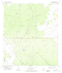
La Pryor NW, Texas, USGS topographic map dated 1972.
Includes geographic coordinates (latitude and longitude). This topographic map is suitable for hiking, camping, and exploring, or framing it as a wall map.
Printed on-demand using high resolution imagery, on heavy weight and acid free paper, or alternatively on a variety of synthetic materials.
Topos available on paper, Waterproof, Poly, or Tyvek. Usually shipping rolled, unless combined with other folded maps in one order.
- Product Number: USGS-5488737
- Free digital map download (high-resolution, GeoPDF): La Pryor NW, Texas (file size: 10 MB)
- Map Size: please refer to the dimensions of the GeoPDF map above
- Weight (paper map): ca. 55 grams
- Map Type: POD USGS Topographic Map
- Map Series: HTMC
- Map Verison: Historical
- Cell ID: 24158
- Scan ID: 110148
- Imprint Year: 1974
- Woodland Tint: Yes
- Visual Version Number: 1
- Aerial Photo Year: 1971
- Field Check Year: 1972
- Datum: NAD27
- Map Projection: Lambert Conformal Conic
- Map published by United States Geological Survey
- Map Language: English
- Scanner Resolution: 600 dpi
- Map Cell Name: La Pryor NW
- Grid size: 7.5 X 7.5 Minute
- Date on map: 1972
- Map Scale: 1:24000
- Geographical region: Texas, United States
Neighboring Maps:
All neighboring USGS topo maps are available for sale online at a variety of scales.
Spatial coverage:
Topo map La Pryor NW, Texas, covers the geographical area associated the following places:
- Horse Trap Tank - Willow Tank - Caballos Windmill - Dawson Windmill - Highway Tank - Turkey Creek Windmill - Alto Colorado Well - Maverick Tank - Hensley Windmill - Lake Windmill - Sevenmile Windmill - Chaparrosa Ranch - Chaparrosa Lake - Rincon Tank - Green Lake - Maverick Creek Windmill - Fourmile Windmill - Bowles Windmill - Oliphant Ranch - Willow Tank Dam - Watkins Lake Number 2 Dam - Highway Pit Tank - Cometa Tank - Rancho Viejo Windmill - Middle Tank - Watkins Lake Number 2 - Latigo Tank - Maverick Creek - Chaparrosa Lake Dam - Dry Tank - Windmill Creek - La Pryor Division - Chaparrosa Ranch Airport - Caliche Tank - Pepe Tank - Kite Windmill - Camisa Tank - Comstock Windmill
- Map Area ID: AREA2928.875-100-99.875
- Northwest corner Lat/Long code: USGSNW29-100
- Northeast corner Lat/Long code: USGSNE29-99.875
- Southwest corner Lat/Long code: USGSSW28.875-100
- Southeast corner Lat/Long code: USGSSE28.875-99.875
- Northern map edge Latitude: 29
- Southern map edge Latitude: 28.875
- Western map edge Longitude: -100
- Eastern map edge Longitude: -99.875


