
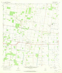
~ La Blanca TX topo map, 1:24000 scale, 7.5 X 7.5 Minute, Historical, 1963, updated 1965
La Blanca, Texas, USGS topographic map dated 1963.
Includes geographic coordinates (latitude and longitude). This topographic map is suitable for hiking, camping, and exploring, or framing it as a wall map.
Printed on-demand using high resolution imagery, on heavy weight and acid free paper, or alternatively on a variety of synthetic materials.
Topos available on paper, Waterproof, Poly, or Tyvek. Usually shipping rolled, unless combined with other folded maps in one order.
- Product Number: USGS-5488619
- Free digital map download (high-resolution, GeoPDF): La Blanca, Texas (file size: 7 MB)
- Map Size: please refer to the dimensions of the GeoPDF map above
- Weight (paper map): ca. 55 grams
- Map Type: POD USGS Topographic Map
- Map Series: HTMC
- Map Verison: Historical
- Cell ID: 24050
- Scan ID: 110083
- Imprint Year: 1965
- Woodland Tint: Yes
- Visual Version Number: 1
- Aerial Photo Year: 1961
- Survey Year: 1963
- Datum: NAD27
- Map Projection: Polyconic
- Map published by United States Geological Survey
- Map Language: English
- Scanner Resolution: 600 dpi
- Map Cell Name: La Blanca
- Grid size: 7.5 X 7.5 Minute
- Date on map: 1963
- Map Scale: 1:24000
- Geographical region: Texas, United States
Neighboring Maps:
All neighboring USGS topo maps are available for sale online at a variety of scales.
Spatial coverage:
Topo map La Blanca, Texas, covers the geographical area associated the following places:
- Rankin Colonia - Jackson's New World Colonia Number 2 - Colonia Claude Lookingbill - Morningside Estates Colonia - Summerwood Colonia - Towne East Colonia Number 1 - Doolittle - Nurillo - San Carlos Acres Colonia - Evergreen - Tropicana Colonia - Harmel Colonia - Tower Heights Colonia - Brenda Gay Colonia - Foster Colonia - Murillo Colonia - FM 1925-Floral Rd Colonia - El Mesquite Colonia - Ricky Colonia - Montemayor Subivision Colonia - Peter Gort Colonia - Isaacs Colonia - Delta-Rodger Colonia - César Chávez - Tower Colonia - Renarae Colonia Number 1 - Rambo Estates Colonia - Ebony Acres Colonia - Palma Colonia - Rodgers Road Colonia - Kenyon Colonia Number 1 - Meadow Lands Colonia - L and P Colonia - Jackson's New World Colonia - Collin Colonia - Loma Chica Colonia - Yokum-Hall Colonia - Schunior's Colonia - Hern Colonia - Monte Cristo Hills Colonia - San Carlos - Bar Number 5 Colonia - Kenyon Colonia Number 2 - Muniz Colonia - Twin Lake Colonia - Sandy Ridge Colonia - Big John Colonia - Ruthven Colonia Number 2 - Hilda Colonia Number 1 - Santa Cruz Estates Colonia - Nelle Estates Colonia - Rancho Nuevo Colonia - Imperial Colonia - Bar Number 2 Colonia - Fleamarket Colonia - Engleman Estates Colonia - Delta West Colonia - D T Villareal Colonia - Muniz - Palmas Colonia Number 2 - Hacienda de los Vegas Colonia - 17 1/2 North-6 West Colonia - Las Brisas Estates Colonia - Southern Breeze Colonia - Rosalito Colonia - Engleman Gardens - Country Terrace Estates Colonia - Oak Colonia - La Blanca - Green Valley Development Subdividion Colonia - Colonia Tejana - San Carlos Farms Colonia - Ruthven Number 1 Colonia
- Map Area ID: AREA26.37526.25-98.125-98
- Northwest corner Lat/Long code: USGSNW26.375-98.125
- Northeast corner Lat/Long code: USGSNE26.375-98
- Southwest corner Lat/Long code: USGSSW26.25-98.125
- Southeast corner Lat/Long code: USGSSE26.25-98
- Northern map edge Latitude: 26.375
- Southern map edge Latitude: 26.25
- Western map edge Longitude: -98.125
- Eastern map edge Longitude: -98


