
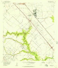
~ Friendswood TX topo map, 1:24000 scale, 7.5 X 7.5 Minute, Historical, 1955, updated 1957
Friendswood, Texas, USGS topographic map dated 1955.
Includes geographic coordinates (latitude and longitude). This topographic map is suitable for hiking, camping, and exploring, or framing it as a wall map.
Printed on-demand using high resolution imagery, on heavy weight and acid free paper, or alternatively on a variety of synthetic materials.
Topos available on paper, Waterproof, Poly, or Tyvek. Usually shipping rolled, unless combined with other folded maps in one order.
- Product Number: USGS-5486369
- Free digital map download (high-resolution, GeoPDF): Friendswood, Texas (file size: 8 MB)
- Map Size: please refer to the dimensions of the GeoPDF map above
- Weight (paper map): ca. 55 grams
- Map Type: POD USGS Topographic Map
- Map Series: HTMC
- Map Verison: Historical
- Cell ID: 72678
- Scan ID: 108326
- Imprint Year: 1957
- Woodland Tint: Yes
- Visual Version Number: 1
- Aerial Photo Year: 1953
- Survey Year: 1955
- Datum: NAD27
- Map Projection: Polyconic
- Map published by United States Geological Survey
- Map Language: English
- Scanner Resolution: 600 dpi
- Map Cell Name: Friendswood
- Grid size: 7.5 X 7.5 Minute
- Date on map: 1955
- Map Scale: 1:24000
- Geographical region: Texas, United States
Neighboring Maps:
All neighboring USGS topo maps are available for sale online at a variety of scales.
Spatial coverage:
Topo map Friendswood, Texas, covers the geographical area associated the following places:
- Baker Editions - Sleepy Hollow - Bay Point - Forest Green - Quaker Village - Sterling Knoll - Friendswood Crossing - Perry Grove - Sterling Wood - Sunwood - Longwood Park - Rustic Oaks - Winding Way Estates - Forestwood - Polly Oaks - Imperial Gardens - Analea White Hall - Bay Knoll - Sunpark - Parkwood Village - Laurelfield - Sheeran Estates - Keystone Meadows - The Forest - Riverwalk - Quaker Landing - Clear Lake - Frenchmans Creek - Scarsdale - Olcott - Regency Estates - Liberty Estates - Friendswood - Humble Camp - Heritage Estates - Lori Woods - Enchanted Woods - Woodcreek - South Bend - Wilderness Trails - Melody Wood - Camino South - Nasawood - Polly Ranch Estates - Greenbriar - Briarwood States - Brook Meadows - Pipers Meadow - Genoa - Oak Brook West - Dixie Hollow - Melody Estates - Baybrook Village - Highland Meadows - Mustang Meadows - Imperial Estates - Goldman Acres - North Fork - Kirkwood - Friendswood Estates - Reese Estates - Bradley Meadows - Sagemont - Sagemont Park - Green Tree Terrace - Bay Glen - Fieldcrest Forest - Friendswood Gardens - Woodmeadow - Poole - Glenshannon - Sunset Meadows - Pineshadows - Marys Creek Estates - Fox Meadows - Eagles Point - Sagemeadow - Sageglen - Regal Oaks - Village Green - Orchard - Brown Acres - Park Place - Clover Acres
- Map Area ID: AREA29.62529.5-95.25-95.125
- Northwest corner Lat/Long code: USGSNW29.625-95.25
- Northeast corner Lat/Long code: USGSNE29.625-95.125
- Southwest corner Lat/Long code: USGSSW29.5-95.25
- Southeast corner Lat/Long code: USGSSE29.5-95.125
- Northern map edge Latitude: 29.625
- Southern map edge Latitude: 29.5
- Western map edge Longitude: -95.25
- Eastern map edge Longitude: -95.125


