
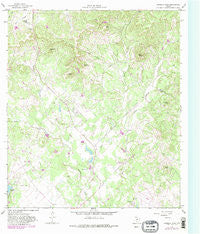
~ Bandera Pass TX topo map, 1:24000 scale, 7.5 X 7.5 Minute, Historical, 1964, updated 1982
Bandera Pass, Texas, USGS topographic map dated 1964.
Includes geographic coordinates (latitude and longitude). This topographic map is suitable for hiking, camping, and exploring, or framing it as a wall map.
Printed on-demand using high resolution imagery, on heavy weight and acid free paper, or alternatively on a variety of synthetic materials.
Topos available on paper, Waterproof, Poly, or Tyvek. Usually shipping rolled, unless combined with other folded maps in one order.
- Product Number: USGS-5482017
- Free digital map download (high-resolution, GeoPDF): Bandera Pass, Texas (file size: 12 MB)
- Map Size: please refer to the dimensions of the GeoPDF map above
- Weight (paper map): ca. 55 grams
- Map Type: POD USGS Topographic Map
- Map Series: HTMC
- Map Verison: Historical
- Cell ID: 2319
- Scan ID: 106335
- Imprint Year: 1982
- Woodland Tint: Yes
- Visual Version Number: 2
- Photo Revision Year: 1982
- Aerial Photo Year: 1979
- Edit Year: 1982
- Field Check Year: 1964
- Datum: NAD27
- Map Projection: Polyconic
- Map published by United States Geological Survey
- Map Language: English
- Scanner Resolution: 600 dpi
- Map Cell Name: Bandera Pass
- Grid size: 7.5 X 7.5 Minute
- Date on map: 1964
- Map Scale: 1:24000
- Geographical region: Texas, United States
Neighboring Maps:
All neighboring USGS topo maps are available for sale online at a variety of scales.
Spatial coverage:
Topo map Bandera Pass, Texas, covers the geographical area associated the following places:
- Joes Point - H and K Lake - Morgan Lake Dam - Round Top - Myrtle Creek - Langford Mountain - Mosher Big Lake - KHLC-FM (Bandera) - Montague Lake - Bandera Pass - Elm Pass - State Mountain - Nanny Trap Mountain - Mosher Little Lake - Mosher Little Lake Dam - Sunset Mountain - Bains Private Airport - Purple Sage Ranch Airfield (historical) - Mosher Big Lake Dam - English Hollow - Eagles Roost Airport (historical) - KHLC-FM (Bandera) - Purple Sage Ranch - Little Mason Creek - Duffys Mountain - Sugarloaf Hill - Polly Peak - Morgan Lake - Bandera County Sheriff's Office - H and K Lake Dam
- Map Area ID: AREA29.87529.75-99.125-99
- Northwest corner Lat/Long code: USGSNW29.875-99.125
- Northeast corner Lat/Long code: USGSNE29.875-99
- Southwest corner Lat/Long code: USGSSW29.75-99.125
- Southeast corner Lat/Long code: USGSSE29.75-99
- Northern map edge Latitude: 29.875
- Southern map edge Latitude: 29.75
- Western map edge Longitude: -99.125
- Eastern map edge Longitude: -99


