
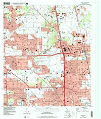
~ Aldine TX topo map, 1:24000 scale, 7.5 X 7.5 Minute, Historical, 1995, updated 1999
Aldine, Texas, USGS topographic map dated 1995.
Includes geographic coordinates (latitude and longitude). This topographic map is suitable for hiking, camping, and exploring, or framing it as a wall map.
Printed on-demand using high resolution imagery, on heavy weight and acid free paper, or alternatively on a variety of synthetic materials.
Topos available on paper, Waterproof, Poly, or Tyvek. Usually shipping rolled, unless combined with other folded maps in one order.
- Product Number: USGS-5481421
- Free digital map download (high-resolution, GeoPDF): Aldine, Texas (file size: 12 MB)
- Map Size: please refer to the dimensions of the GeoPDF map above
- Weight (paper map): ca. 55 grams
- Map Type: POD USGS Topographic Map
- Map Series: HTMC
- Map Verison: Historical
- Cell ID: 477
- Scan ID: 121934
- Imprint Year: 1999
- Woodland Tint: Yes
- Visual Version Number: 2
- Aerial Photo Year: 1995
- Datum: NAD83
- Map Projection: Universal Transverse Mercator
- Map published by United States Geological Survey
- Map Language: English
- Scanner Resolution: 600 dpi
- Map Cell Name: Aldine
- Grid size: 7.5 X 7.5 Minute
- Date on map: 1995
- Map Scale: 1:24000
- Geographical region: Texas, United States
Neighboring Maps:
All neighboring USGS topo maps are available for sale online at a variety of scales.
Spatial coverage:
Topo map Aldine, Texas, covers the geographical area associated the following places:
- Heather Glen - Blue Bell Manor - Lincoln Green South - Southbrook - Inwood West - Fountainhead - Gum Valley - Greenbranch - Lincoln City - Northcliffe Manor - Airline Terrace - Airline Estates - Aldine - Traweek Gardens - Northborough - Glen Forest - Yale Gardens - Blue Bell Place - Recreation Farms - Oak Glen Place - Greenfield Village - Lincoln Green East - Garden City Park - Imperial Valley - Willow Run - Ridge Point - North Country - Champions Point - Inwood Forest - Airline Farms - Briar Creek - McKamy Meadow - Hidden Valley - Northline Terrace - Highland Gardens
- Map Area ID: AREA3029.875-95.5-95.375
- Northwest corner Lat/Long code: USGSNW30-95.5
- Northeast corner Lat/Long code: USGSNE30-95.375
- Southwest corner Lat/Long code: USGSSW29.875-95.5
- Southeast corner Lat/Long code: USGSSE29.875-95.375
- Northern map edge Latitude: 30
- Southern map edge Latitude: 29.875
- Western map edge Longitude: -95.5
- Eastern map edge Longitude: -95.375


