
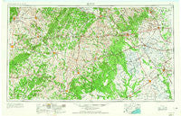
~ Seguin TX topo map, 1:250000 scale, 1 X 2 Degree, Historical, 1953, updated 1965
Seguin, Texas, USGS topographic map dated 1953.
Includes geographic coordinates (latitude and longitude). This topographic map is suitable for hiking, camping, and exploring, or framing it as a wall map.
Printed on-demand using high resolution imagery, on heavy weight and acid free paper, or alternatively on a variety of synthetic materials.
Topos available on paper, Waterproof, Poly, or Tyvek. Usually shipping rolled, unless combined with other folded maps in one order.
- Product Number: USGS-5481143
- Free digital map download (high-resolution, GeoPDF): Seguin, Texas (file size: 18 MB)
- Map Size: please refer to the dimensions of the GeoPDF map above
- Weight (paper map): ca. 55 grams
- Map Type: POD USGS Topographic Map
- Map Series: HTMC
- Map Verison: Historical
- Cell ID: 69023
- Scan ID: 121892
- Imprint Year: 1965
- Woodland Tint: Yes
- Visual Version Number: 1
- Aerial Photo Year: 1953
- Edit Year: 1965
- Field Check Year: 1953
- Datum: Unstated
- Map Projection: Transverse Mercator
- Map published by United States Geological Survey
- Map Language: English
- Scanner Resolution: 600 dpi
- Map Cell Name: Seguin
- Grid size: 1 X 2 Degree
- Date on map: 1953
- Map Scale: 1:250000
- Geographical region: Texas, United States
Neighboring Maps:
All neighboring USGS topo maps are available for sale online at a variety of scales.
Spatial coverage:
Topo map Seguin, Texas, covers the geographical area associated the following places:
- Ganado - Watts - Lone Oak - Oak Forest - Delhi - Sorrelle - Saint James - Cheapside - Lafitte - Novohrad - Speaks - Pettytown - Lefman - Lane City - Gleckler - Dugger - Reedville - Plum - Ezzell - Jeddo - Ottine - Mullins Prairie - Plummer Crossing - Mount Olive - Alum - Steen - Rayner Junction - Cistern - Luling - Union - Bateman - Eldridge - Staples - Togo - Cestohowa - Sublime - Vienna - New Bremen - Sandy Fork - Ammannsville - Frelsburg - Taiton (historical) - Holman - Sweet Home - Verhelle - Ecleto - Joiner - Fords Prairie - Witting - Brownsboro - Lakeside - Fordtran - Engle - Mackay - La Grange - Little New York - Smiley - Kubala Store - Kokernot - Oldenburg - Jakes Colony - Lockhart - Hochheim - Sand Ridge - Pierce - Jones Creek - Worthing - Stratton - Millheim - Burleigh - Rexville - Kyle - Elm Grove - Denhawken - Gruenau - Seguin - Martindale - Vsetin - Sunny Side - Rockhouse - Atascosito Crossing (historical) - Stellar - Newtonville - Galle - Cat Spring - Tamberg - Pearl City - Shaws Bend - Leesville - Laban - Saturn - Monaville - Geronimo - New Ulm - Saint John - Hickston - Eagle Lake - Yokum - Oakland - Wrightsboro
- Map Area ID: AREA3029-98-96
- Northwest corner Lat/Long code: USGSNW30-98
- Northeast corner Lat/Long code: USGSNE30-96
- Southwest corner Lat/Long code: USGSSW29-98
- Southeast corner Lat/Long code: USGSSE29-96
- Northern map edge Latitude: 30
- Southern map edge Latitude: 29
- Western map edge Longitude: -98
- Eastern map edge Longitude: -96


