
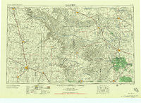
~ Plainview TX topo map, 1:250000 scale, 1 X 2 Degree, Historical, 1958, updated 1958
Plainview, Texas, USGS topographic map dated 1958.
Includes geographic coordinates (latitude and longitude). This topographic map is suitable for hiking, camping, and exploring, or framing it as a wall map.
Printed on-demand using high resolution imagery, on heavy weight and acid free paper, or alternatively on a variety of synthetic materials.
Topos available on paper, Waterproof, Poly, or Tyvek. Usually shipping rolled, unless combined with other folded maps in one order.
- Product Number: USGS-5481097
- Free digital map download (high-resolution, GeoPDF): Plainview, Texas (file size: 19 MB)
- Map Size: please refer to the dimensions of the GeoPDF map above
- Weight (paper map): ca. 55 grams
- Map Type: POD USGS Topographic Map
- Map Series: HTMC
- Map Verison: Historical
- Cell ID: 68962
- Scan ID: 116261
- Imprint Year: 1958
- Woodland Tint: Yes
- Visual Version Number: 1
- Aerial Photo Year: 1954
- Field Check Year: 1954
- Datum: Unstated
- Map Projection: Transverse Mercator
- Map published by United States Army Corps of Engineers
- Map published by United States Army
- Map Language: English
- Scanner Resolution: 600 dpi
- Map Cell Name: Plainview
- Grid size: 1 X 2 Degree
- Date on map: 1958
- Map Scale: 1:250000
- Geographical region: Texas, United States
Neighboring Maps:
All neighboring USGS topo maps are available for sale online at a variety of scales.
Spatial coverage:
Topo map Plainview, Texas, covers the geographical area associated the following places:
- Smithdale - Lesley - Seth Ward - Paloduro - Edmonson - Lider - Boone - Jacobs (historical) - Carey - Ogg - Turkey - Tulia - Hedley - Whitestar - Loco - Swearingen - Six Point - Gray Mule - Baker - Wayside - Vigo Park - Giles - Wasson - Woodburn Place - Lelia Lake - Happy Union - Eli - McKnight - Narcisso - Plaska - Estelline - Hulver - Fairmont - Newlin - Antelope Flats - Lockney - Lakeview - Plainview - Wright - Cleta - Kirkland - Cereal - Lakeview - Finney - Weatherly - Cee Vee - Brice - South Brice - Parnell - Ellen - Snyder - Aiken - Halfway - Rock Creek - Center Plains - Flomot - Sterley - Abington - Quail - Matador - Paducah - Crume Gin - Whitney - Dunlap - Whiteflat - Memphis - Ogden - Marilla - Hale Center - Furguson - Plains Junction - Wellington - Mayfield - Swearingen - South Plains - Muncy - Canyon - Lone Star - Quitaque - Happy - Johnfarris - Cedar Hill - Coleyville - Hale City (historical) - Eunice - Tell - Childress - New Loco - Clarendon - Providence - Silverton - Kaffir - Kress - Northfield - Claytonville - Arlie - Rolla - Dodson - Folley - Fresno
- Map Area ID: AREA3534-102-100
- Northwest corner Lat/Long code: USGSNW35-102
- Northeast corner Lat/Long code: USGSNE35-100
- Southwest corner Lat/Long code: USGSSW34-102
- Southeast corner Lat/Long code: USGSSE34-100
- Northern map edge Latitude: 35
- Southern map edge Latitude: 34
- Western map edge Longitude: -102
- Eastern map edge Longitude: -100


