
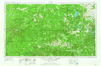
~ Llano TX topo map, 1:250000 scale, 1 X 2 Degree, Historical, 1954, updated 1964
Llano, Texas, USGS topographic map dated 1954.
Includes geographic coordinates (latitude and longitude). This topographic map is suitable for hiking, camping, and exploring, or framing it as a wall map.
Printed on-demand using high resolution imagery, on heavy weight and acid free paper, or alternatively on a variety of synthetic materials.
Topos available on paper, Waterproof, Poly, or Tyvek. Usually shipping rolled, unless combined with other folded maps in one order.
- Product Number: USGS-5481037
- Free digital map download (high-resolution, GeoPDF): Llano, Texas (file size: 19 MB)
- Map Size: please refer to the dimensions of the GeoPDF map above
- Weight (paper map): ca. 55 grams
- Map Type: POD USGS Topographic Map
- Map Series: HTMC
- Map Verison: Historical
- Cell ID: 68879
- Scan ID: 109272
- Imprint Year: 1964
- Woodland Tint: Yes
- Visual Version Number: 1
- Aerial Photo Year: 1953
- Edit Year: 1964
- Field Check Year: 1954
- Datum: Unstated
- Map Projection: Transverse Mercator
- Map published by United States Army Corps of Engineers
- Map published by United States Army
- Map Language: English
- Scanner Resolution: 600 dpi
- Map Cell Name: Llano
- Grid size: 1 X 2 Degree
- Date on map: 1954
- Map Scale: 1:250000
- Geographical region: Texas, United States
Neighboring Maps:
All neighboring USGS topo maps are available for sale online at a variety of scales.
Spatial coverage:
Topo map Llano, Texas, covers the geographical area associated the following places:
- Koockville - Pontotoc - Meadowlakes - Watson - Llano - Shovel Mountain - Lone Grove - Lakeside Heights - Sudduth - Junction - Payton - Noxville - Crabapple - Fredericksburg - Cherry Spring - Cherokee - Smithwick - Sherwood Shores - Round Mountain - Scobee - Hilltop - Waltonia - Cottonwood Shores - Junction Windmill - Loyal Valley - Stonewall - Castell - Stowers Corner Windmill - Grossville - Cypress Mill - Beyer Crossing - Buchanan Dam - Blowout - Ingram - Burnet - Hext - Stolz - Blumenthal - Hammetts Crossing - Mason - Twin Sisters - Baby Head (historical) - Post Oak - Oatmeal - Westbrook (historical) - Katemcy - Oxford - Sunnylane - Gandy - Sunnylane - Cleo - Willow City - Field Creek - Fivemile Crossing - Albert - Scotts Crossing - Morris Ranch - Hilda - Legion - Woodcreek - Blanco - Click - Saline - Shady Grove - Johnson City - Yates - Telegraph - Fairland - Bankersmith - Bluffton - Marble Falls - Gainesville - Tenmile Crossing - Lindendale - Rocky Hill - Joppa - Kerrville - Sandy - Fitzhugh - Grapetown - Camp San Saba - Valley Spring - Tow - Sunrise Beach Village - Shovel Mountain - Twentymile Crossing - Hye - Driftwood - Mountain Home - Mount Gainor - Kingsland - Flugrath - Erna - Prairie Mountain - Spicewood - Henly - Rocky Creek - Segovia - London - Fourmile Crossing
- Map Area ID: AREA3130-100-98
- Northwest corner Lat/Long code: USGSNW31-100
- Northeast corner Lat/Long code: USGSNE31-98
- Southwest corner Lat/Long code: USGSSW30-100
- Southeast corner Lat/Long code: USGSSE30-98
- Northern map edge Latitude: 31
- Southern map edge Latitude: 30
- Western map edge Longitude: -100
- Eastern map edge Longitude: -98


