
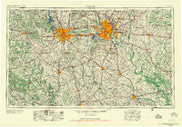
~ Dallas TX topo map, 1:250000 scale, 1 X 2 Degree, Historical, 1958
Dallas, Texas, USGS topographic map dated 1958.
Includes geographic coordinates (latitude and longitude). This topographic map is suitable for hiking, camping, and exploring, or framing it as a wall map.
Printed on-demand using high resolution imagery, on heavy weight and acid free paper, or alternatively on a variety of synthetic materials.
Topos available on paper, Waterproof, Poly, or Tyvek. Usually shipping rolled, unless combined with other folded maps in one order.
- Product Number: USGS-5480971
- Free digital map download (high-resolution, GeoPDF): Dallas, Texas (file size: 21 MB)
- Map Size: please refer to the dimensions of the GeoPDF map above
- Weight (paper map): ca. 55 grams
- Map Type: POD USGS Topographic Map
- Map Series: HTMC
- Map Verison: Historical
- Cell ID: 68738
- Scan ID: 109080
- Woodland Tint: Yes
- Visual Version Number: 1
- Aerial Photo Year: 1953
- Field Check Year: 1954
- Datum: Unstated
- Map Projection: Transverse Mercator
- Map published by United States Geological Survey
- Map published by United States Army Corps of Engineers
- Map Language: English
- Scanner Resolution: 600 dpi
- Map Cell Name: Dallas
- Grid size: 1 X 2 Degree
- Date on map: 1958
- Map Scale: 1:250000
- Geographical region: Texas, United States
Neighboring Maps:
All neighboring USGS topo maps are available for sale online at a variety of scales.
Spatial coverage:
Topo map Dallas, Texas, covers the geographical area associated the following places:
- Waxahachie - Hurst - Allison - Rylie - Preble - Ables Springs - Everman - Waples - Becker - Valley Farms - Cresson - Watauga - Sachse - Eagle Acres - Pecan Acres - Rockett - Lone Oak - Tate Springs - Eustace - Tupelo - Sand Lake - Whitehead - White Settlement - Southland Acres - Bisbee - Lakeside Village - Five Points - Avondale - Red Bird Addition - Glen Hill - Pettys Chapel - Elm Flat - University Park Village - Millwood - Farmers Branch - Red Oak - Lake Forest - Webb - Alvarado - Oak Hill - Blackland - Tarrant - Pauline - Goshen - Shiloh - Gribble - Florence Hill - Rainbow - Cash - Payne Springs - Blum - Round Prairie - Mountain Peak - Agnes - Seagoville - Eagle Ford - Italy - Bobwyn - Drane - Palmer - Joshua - Kingswood - Dalworthington Gardens - Odom - Ensign - Sand Flat - Dresden - Brandon - Cleburne - Glen Rose - Castle Hill Estate - Lancaster - Rendon - Frost - Aley - Weatherford - Bell Branch - Marystown - Plover - Mountain View - Old Union - Retta - River Oaks - Wise - Chalk Mountain - Acton - Advance - Walnut Springs - Mildred - Coppell - Edgecliff Village - Rawlins - Pantego - Lake Crest Estates - Punkin Center - Pleasant Point - Red Hill - El Tesoro - Earls - Cockrell Hill
- Map Area ID: AREA3332-98-96
- Northwest corner Lat/Long code: USGSNW33-98
- Northeast corner Lat/Long code: USGSNE33-96
- Southwest corner Lat/Long code: USGSSW32-98
- Southeast corner Lat/Long code: USGSSE32-96
- Northern map edge Latitude: 33
- Southern map edge Latitude: 32
- Western map edge Longitude: -98
- Eastern map edge Longitude: -96


