
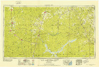
~ Crystal City TX topo map, 1:250000 scale, 1 X 2 Degree, Historical, 1953, updated 1953
Crystal City, Texas, USGS topographic map dated 1953.
Includes geographic coordinates (latitude and longitude). This topographic map is suitable for hiking, camping, and exploring, or framing it as a wall map.
Printed on-demand using high resolution imagery, on heavy weight and acid free paper, or alternatively on a variety of synthetic materials.
Topos available on paper, Waterproof, Poly, or Tyvek. Usually shipping rolled, unless combined with other folded maps in one order.
- Product Number: USGS-5480951
- Free digital map download (high-resolution, GeoPDF): Crystal City, Texas (file size: 14 MB)
- Map Size: please refer to the dimensions of the GeoPDF map above
- Weight (paper map): ca. 55 grams
- Map Type: POD USGS Topographic Map
- Map Series: HTMC
- Map Verison: Historical
- Cell ID: 72225
- Scan ID: 108986
- Imprint Year: 1953
- Woodland Tint: Yes
- Visual Version Number: 1
- Aerial Photo Year: 1948
- Datum: NAD27
- Map Projection: Transverse Mercator
- Map published by United States Army Corps of Engineers
- Map published by United States Army
- Map Language: English
- Scanner Resolution: 600 dpi
- Map Cell Name: Crystal City
- Grid size: 1 X 2 Degree
- Date on map: 1953
- Map Scale: 1:250000
- Geographical region: Texas, United States
Neighboring Maps:
All neighboring USGS topo maps are available for sale online at a variety of scales.
Spatial coverage:
Topo map Crystal City, Texas, covers the geographical area associated the following places:
- Peggy - Crown - Seven Sisters - Midway - Crystal City - Ray Point - Fowlerton - Triangula Colonia - Cross - Mays Crossing - Campbellton - Frio Heights Colonia - Esseville - Coughran - Derby - Goldfinch - Carrizo Hill - River Spur - River Creek Acres - Whitsett - Artesia Wells - Hilltop - Kearny - Coy City - Conquista Crossing - Pearsall - Chula Vista Colonia - Christine - Brundage - El Oso - Millett - Dobrowolski - La Hacienda Estates Number 2 Colonia - Zella - Asherton - Davis - Loma Alta - La Parrita Valley Colonia - Nell - Schattel - Mikeska - Oaks - Dull - Derby Colonia - Vally-Hi Acres Number 2 Colonia - Ike - Falls City - Las Colonias - Big Wells - Hilltop Colonia - Miguel - Hindes - Jourdanton - Cude Crossing Windmill - Winter Haven - Deweesville - Three Oaks - Rancho de la Parita - Zamora Acres Colonia - Simmons - Gardendale - Tilden - Los Angeles - Oakville - McCoy - North Pearsall - Carrizo Springs - Leal - Pawnee - Black Hill - Popeye Lake Colonia - Batesville - La Parita - Melon - Parks Corner Windmill - Catarina - Nueces Campsite Lots Colonia - Gilson Groves - Clegg - Dilley - Pleasanton - Crowther - Amaya Colonia - Valley Wells - Three Rivers - Divot - Orelia - West Pearsall - George West - Cotulla - Bushy Creek Colonia - Las Flores - Fashing - Calliham - Pearsall East Colonia - Espantosa Colonia - Karon - Encinal - Carrizo Hills Colonia - Camposanto-Elcometa Colonia
- Map Area ID: AREA2928-100-98
- Northwest corner Lat/Long code: USGSNW29-100
- Northeast corner Lat/Long code: USGSNE29-98
- Southwest corner Lat/Long code: USGSSW28-100
- Southeast corner Lat/Long code: USGSSE28-98
- Northern map edge Latitude: 29
- Southern map edge Latitude: 28
- Western map edge Longitude: -100
- Eastern map edge Longitude: -98


