
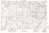
~ Brownfield TX topo map, 1:250000 scale, 1 X 2 Degree, Historical, 1954, updated 1975
Brownfield, Texas, USGS topographic map dated 1954.
Includes geographic coordinates (latitude and longitude). This topographic map is suitable for hiking, camping, and exploring, or framing it as a wall map.
Printed on-demand using high resolution imagery, on heavy weight and acid free paper, or alternatively on a variety of synthetic materials.
Topos available on paper, Waterproof, Poly, or Tyvek. Usually shipping rolled, unless combined with other folded maps in one order.
- Product Number: USGS-5480927
- Free digital map download (high-resolution, GeoPDF): Brownfield, Texas (file size: 14 MB)
- Map Size: please refer to the dimensions of the GeoPDF map above
- Weight (paper map): ca. 55 grams
- Map Type: POD USGS Topographic Map
- Map Series: HTMC
- Map Verison: Historical
- Cell ID: 68692
- Scan ID: 108195
- Imprint Year: 1975
- Woodland Tint: Yes
- Visual Version Number: 2
- Aerial Photo Year: 1954
- Edit Year: 1973
- Field Check Year: 1954
- Datum: NAD27
- Map Projection: Transverse Mercator
- Map published by: Military, Other
- Map Language: English
- Scanner Resolution: 600 dpi
- Map Cell Name: Brownfield
- Grid size: 1 X 2 Degree
- Date on map: 1954
- Map Scale: 1:250000
- Geographical region: Texas, United States
Neighboring Maps:
All neighboring USGS topo maps are available for sale online at a variety of scales.
Spatial coverage:
Topo map Brownfield, Texas, covers the geographical area associated the following places:
- Caprock - Sligo - Bledsoe - Plains - Reese Village - Pep - Beatty Wells - Maple - Arnett - Wolfforth - Spade - Pleasant Hill - Ropesville - Brownfield - Girlstown USA - Famuliner - Gladiola - Beck - Clauene - Wellman - Smyer - Gomez - Elida - Star Route (historical) - Bula - Robertson Wells - Hillburn City - Boaz - Roundup - Lahey - Coble - Lums Chapel - Red Lake (historical) - Meadow - Prairieview - Levelland - Griffith - Lone Wolf - Pep - Johnson - Corner Well - Home Place Well - Oklahoma Flat - Bronco - Dora - Tokio - Lehman - Whitharral - Opdyke West - Garrison - Goodland - Pep - Morton - Rogers - Crossroads - Tatum - Needmore - Kenna - McDonald - Hurlwood - Peveler Place - Opdyke - Vest Wells - Tornero - Pettit - Friendship - Milnesand - Lingo - Richland - Whiteface - Goodland - New Moore - Sundown - New Hope (historical) - Bluit - Union - Lockettville - Enochs - Bainer - Neely Ward - Foster - Anton - Lakeview - Longs (historical) - West Point - Littlefield - Inez - Causey - Eagle Hill (historical)
- Map Area ID: AREA3433-104-102
- Northwest corner Lat/Long code: USGSNW34-104
- Northeast corner Lat/Long code: USGSNE34-102
- Southwest corner Lat/Long code: USGSSW33-104
- Southeast corner Lat/Long code: USGSSE33-102
- Northern map edge Latitude: 34
- Southern map edge Latitude: 33
- Western map edge Longitude: -104
- Eastern map edge Longitude: -102


