
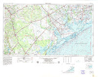
~ Beeville TX topo map, 1:250000 scale, 1 X 2 Degree, Historical, 1956, updated 1980
Beeville, Texas, USGS topographic map dated 1956.
Includes geographic coordinates (latitude and longitude). This topographic map is suitable for hiking, camping, and exploring, or framing it as a wall map.
Printed on-demand using high resolution imagery, on heavy weight and acid free paper, or alternatively on a variety of synthetic materials.
Topos available on paper, Waterproof, Poly, or Tyvek. Usually shipping rolled, unless combined with other folded maps in one order.
- Product Number: USGS-5480915
- Free digital map download (high-resolution, GeoPDF): Beeville, Texas (file size: 15 MB)
- Map Size: please refer to the dimensions of the GeoPDF map above
- Weight (paper map): ca. 55 grams
- Map Type: POD USGS Topographic Map
- Map Series: HTMC
- Map Verison: Historical
- Cell ID: 74957
- Scan ID: 707221
- Imprint Year: 1980
- Woodland Tint: Yes
- Visual Version Number: 1
- Edit Year: 1978
- Field Check Year: 1956
- Datum: NAD27
- Map Projection: Transverse Mercator
- Map published by United States Geological Survey
- Map Language: English
- Scanner Resolution: 508 dpi
- Map Cell Name: Beeville
- Grid size: 1 X 2 Degree
- Date on map: 1956
- Map Scale: 1:250000
- Geographical region: Texas, United States
Neighboring Maps:
All neighboring USGS topo maps are available for sale online at a variety of scales.
Spatial coverage:
Topo map Beeville, Texas, covers the geographical area associated the following places:
- Third Rancho Chico Addition Colonia - O'Farrell Acres Number 1 Colonia - Cranell - Argenta - Saint Paul - Placedo - Edgewater Estates Number 3 Colonia - Kenedy - Wadeside Addition Colonia - Dupre - Bloomington - Raisin - Bonnie View - Lakewood Heights - Peace Valley Harbor - Salem - Angel City - Helena - Port Lavaca - Lolita - Lakeshore Gardens Number 2 Colonia - Karnes City - Spanish Village - Sunkist Country Estates Colonia - La Ward - Lake City - Coletoville - Vahlsing - Buena Vista Colonia - Blanconia - Sandia Gardens Colonia - Red Bluff - Arneckeville - Austwell - Magnolia Beach - 1st, 2nd, and 3rd Street Area Colonia - Alamo Beach - Cologne - Skidmore - Port Alto - Victoria - Morgan Farm Colonia - Hodges Addition Colonia - Burnell - Tivoli - Mathis - Rozypal Estates Colonia - Blue Berry Hill - Lakeshore Gardens Number 1 Colonia - Moursund - Bayside - McFaddin - Del Sol Colonia - Shady Acres Colonia - Fannin - Green Lake - Saint Paul - Corriente Estates Colonia - Blue Berry Hill Colonia - Point Loma - Salazar Heights Colonia - Saint Paul Number 1 Colonia - Wood Hi - Blessing - La Para - Ryanville - Heldnfelt - Lake Mathis Point Colonia - Dodd Number 2 Colonia - John L Norris Colonia - Mount Lucas - El Toro - Kilgore - Bayview Estates Colonia - Dinero - Gonzales 12 Colonia - Woodsboro - Mineral - Ander - Normanna - Elmaton - Yorktown - Lamar - Vidaurri - North Lakeshore Gardens Colonia - Simpsonville - Nordheim - Olivia - Francitas - Old Saint Marys - Manson - Sarco - Dodd Colonia - Oak Village - Hidden Acres - Midfield - Inari - Hideaway Hill - Meyersville - Telferner
- Map Area ID: AREA2928-98-96
- Northwest corner Lat/Long code: USGSNW29-98
- Northeast corner Lat/Long code: USGSNE29-96
- Southwest corner Lat/Long code: USGSSW28-98
- Southeast corner Lat/Long code: USGSSE28-96
- Northern map edge Latitude: 29
- Southern map edge Latitude: 28
- Western map edge Longitude: -98
- Eastern map edge Longitude: -96


