
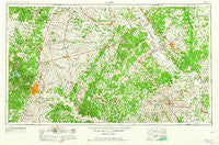
~ Austin TX topo map, 1:250000 scale, 1 X 2 Degree, Historical, 1954, updated 1964
Austin, Texas, USGS topographic map dated 1954.
Includes geographic coordinates (latitude and longitude). This topographic map is suitable for hiking, camping, and exploring, or framing it as a wall map.
Printed on-demand using high resolution imagery, on heavy weight and acid free paper, or alternatively on a variety of synthetic materials.
Topos available on paper, Waterproof, Poly, or Tyvek. Usually shipping rolled, unless combined with other folded maps in one order.
- Product Number: USGS-5480877
- Free digital map download (high-resolution, GeoPDF): Austin, Texas (file size: 19 MB)
- Map Size: please refer to the dimensions of the GeoPDF map above
- Weight (paper map): ca. 55 grams
- Map Type: POD USGS Topographic Map
- Map Series: HTMC
- Map Verison: Historical
- Cell ID: 68656
- Scan ID: 108171
- Imprint Year: 1964
- Woodland Tint: Yes
- Visual Version Number: 1
- Aerial Photo Year: 1953
- Edit Year: 1963
- Field Check Year: 1954
- Datum: Unstated
- Map Projection: Transverse Mercator
- Map published by United States Army Corps of Engineers
- Map published by United States Army
- Map Language: English
- Scanner Resolution: 600 dpi
- Map Cell Name: Austin
- Grid size: 1 X 2 Degree
- Date on map: 1954
- Map Scale: 1:250000
- Geographical region: Texas, United States
Neighboring Maps:
All neighboring USGS topo maps are available for sale online at a variety of scales.
Spatial coverage:
Topo map Austin, Texas, covers the geographical area associated the following places:
- Elroy - Fedor - Sauney Stand - Valley Junction - Waldeck - Barton - Goodwill - Beyersville - Warrenton - Bundy Crossing - Hearne - Cameron - Turnersville - Grassyville - Pin Oak - Liberty Hill - Iglehart - San Antonio Prairie - Walburg - Little River-Academy - Serenada - Sweet Home - Taylor - Navasota - Hare - Rogers - Rehburg - Edge - Big Creek - Turkey Hollow - Buckholts - Siloam - Edgewater Beach - Ding Dong - Davidson - Union - Keith - Daffan - Belmena - Sonterra - Deanville - Boonville - New Wehdem - Briggs - Bear Creek - Meeks - Rices Crossing - La Bahia - Spear - Round Mountain - Camp Swift - North Shore Acres - Merrelltown - Hogg - Sempronius (historical) - Haw Creek (historical) - Chances Store - Maha - Allenfarm - Phillipsburg - Friendship - Cochran - Hills - Koppe - Cedar Valley - Bee Cave - Andice - Walkerton - Channey Crossing - Howth - Weir - Frame Switch - Wixon Valley - Tanglewood Forest - Salem - Sandoval - Hays City - River Hills - New Colony - Harvey - George - Upton - Eubank Acres - Dunlap - Keelersville - Forest Grove - Niederwald - Barton Creek - Volente - Clay - McDade - Warda - Webberville - Coupland - Manor - Villa Siesta Retirement Village - Corn Hill - Liberty Hill - Smoot - Bowers
- Map Area ID: AREA3130-98-96
- Northwest corner Lat/Long code: USGSNW31-98
- Northeast corner Lat/Long code: USGSNE31-96
- Southwest corner Lat/Long code: USGSSW30-98
- Southeast corner Lat/Long code: USGSSE30-96
- Northern map edge Latitude: 31
- Southern map edge Latitude: 30
- Western map edge Longitude: -98
- Eastern map edge Longitude: -96


