
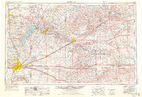
~ Amarillo TX topo map, 1:250000 scale, 1 X 2 Degree, Historical, 1954, updated 1976
Amarillo, Texas, USGS topographic map dated 1954.
Includes geographic coordinates (latitude and longitude). This topographic map is suitable for hiking, camping, and exploring, or framing it as a wall map.
Printed on-demand using high resolution imagery, on heavy weight and acid free paper, or alternatively on a variety of synthetic materials.
Topos available on paper, Waterproof, Poly, or Tyvek. Usually shipping rolled, unless combined with other folded maps in one order.
- Product Number: USGS-5480875
- Free digital map download (high-resolution, GeoPDF): Amarillo, Texas (file size: 15 MB)
- Map Size: please refer to the dimensions of the GeoPDF map above
- Weight (paper map): ca. 55 grams
- Map Type: POD USGS Topographic Map
- Map Series: HTMC
- Map Verison: Historical
- Cell ID: 68644
- Scan ID: 707191
- Imprint Year: 1976
- Visual Version Number: 0
- Aerial Photo Year: 1972
- Edit Year: 1975
- Field Check Year: 1954
- Datum: Unstated
- Map Projection: Transverse Mercator
- Map published by United States Geological Survey
- Map Language: English
- Scanner Resolution: 508 dpi
- Map Cell Name: Amarillo
- Grid size: 1 X 2 Degree
- Date on map: 1954
- Map Scale: 1:250000
- Geographical region: Texas, United States
Neighboring Maps:
All neighboring USGS topo maps are available for sale online at a variety of scales.
Spatial coverage:
Topo map Amarillo, Texas, covers the geographical area associated the following places:
- Jericho - Gageby - Ramsdell - Sheerin - Fuller - Canadian - Panhandle - Amarillo - Mendota - Oil City - Lark - Texroy - Exell - Marsh - Dreyfoos - Puente - Clear Creek - Fritch - Lutie - Chunky - Palisades - Pringle - Stinnett - White Deer - Mayer - Soncy - Washburn - Wilhelm - Claude - Lela - Dozier - Fairview - Codman - Phillips - Four Way - Springers Ranch (historical) - Parnell (historical) - Dumas Junction - Laketon - Howardwick - Masterson - Pleasant Valley - Sanford - Folsom - Briscoe - Lake Tanglewood - Aberdeen - Kellerville - Lefors - Miami - Ashtola - Mesilla Park - Hoover - Timbercreek Canyon - Bishop Hills - Rockledge - Lora - Dial - Skellytown - Abell - Kingsmill Camp - Masterson - Kingsmill - Alanreed - Heaton - McBride - Cargray - Yarnall - Lee - Pomeroy - Plemons - Benonine - Saint Francis - Samnorwood - Norrick - Bowers City - Bellco - Cliffside - Machovec - Conway - Stekoll Camp - Wayside - Gentry - Twitty - Juilliard - Groom - Electric City - Denworth - Hillard - Mobeetie - Malden - Goodnight - Boydston - Bunavista - New Mobeetie - McLean - Kelton - Pakan - Dumas - Shamrock
- Map Area ID: AREA3635-102-100
- Northwest corner Lat/Long code: USGSNW36-102
- Northeast corner Lat/Long code: USGSNE36-100
- Southwest corner Lat/Long code: USGSSW35-102
- Southeast corner Lat/Long code: USGSSE35-100
- Northern map edge Latitude: 36
- Southern map edge Latitude: 35
- Western map edge Longitude: -102
- Eastern map edge Longitude: -100


